
Screaming Zone
Screaming Zone
Etymology
The name ‘Kreischgebiet’ is derived from the three rivers: the Schnelle Kreisch (Romanian: Crișul repede; Hungarian: Sebes-Körös), the Schwarze Kreisch (Romanian: Crișul negru; Hungarian: Fekete-Körös) and the White Kreisch (Romanian: Crișul alb; Hungarian: Fehér-Körös), which flow through the region.
Location and topography
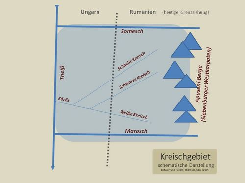
The Kreisch region lies between 20° 45’ and 22° 39’ east longitude, 45° 58’ and 46° 38’ north latitude. It is crossed by three rivers flowing from east to west (from north to south) from the Apuseni Mountains (Romanian: Munții Apuseni; Hungarian: Erdély-Középhegység): the Fast Kreisch, the Black Kreisch and the White Kreisch. The latter converge at Gyula; the Fast Kreisch joins this section – also known as the ‘Double Kreisch’ (Romanian: Crișul dublu; Hungarian: Kettős-Körös) – at Gyomaendrőd to form the ‘Triple Kreisch’ (Romanian: Crișul triplu; Hungarian: Hármas-Körös), which is also simply called the Kreisch (Crișul; Körös) and flows into the Tisza (Romanian: Tisa; Hungarian: Tisza) at Csóngrad. The northern boundary of the Kreisch region is marked by the Somesch (Romanian: Someș; Hungarian: Szamos); to the west, the region is bounded by the Tisza Bend; to the south, the Marosch (Romanian: Mureș; Hungarian: Maros) forms the natural boundary. To the east, the Kreisch region merges into the Transylvanian Western Carpathians, or the Apuseni Mountains, a limestone formation with karst landscapes situated above the western inner end of the Carpathian Arc.
Accordingly, the Kreisch region forms the transitional zone between the mountainous terrain (the Apuseni Mountains) and the Pannonian Plain (Alföld); whilst the eastern part consists of mountainous and hilly landscapes, the western part forms the eastern end of the Pannonian (or: Great Hungarian) Plain.
Historical Geography
The historical term ‘Kreischgebiet’ refers to natural geographical features; the regional designation never had any administrative significance. What was far more significant in this context were the names of the historic Hungarian counties that made up the region and which were continued as administrative units through the Romanian counties (județe) of Arad, Bihor, Sathmar (Romanian: Satu Mare) and also Marmarosch (Romanian: Maramureș), as well as the present-day Hungarian counties, which continue as administrative units in terms of both name and geography (though not always within their original boundaries). The historical district area extends across the present-day Romanian counties of Bihor and Arad, as well as smaller southern parts of Satu Mare County, the western parts of Sălaj County (Romanian: Sălaj) and the northern tip of Hunedoara County. On the Hungarian side, the Kreisch region comprises (from north-east to south-west, in varying proportions) firstly Szabolcs-Sathmar County (Hungarian: Szabolcs-Szatmár-Bereg; county town Nyíregháza) with parts of the historic county of Sathmar (Hungarian: Szatmár; the main part of which belongs to Romania as Satu-Mare County ) and the remnants of the historic county of Bereg (the main part of which belongs to Ukraine, Transcarpathian Oblast [Ukrainian: Oblast’ Zakarpats’ka]), and secondly, Hajdú-Bihar County (county town: Debrezin/Debrecen), formed by the amalgamation of the historic Hajdú County with the remaining parts of the historic Bihar County (the greater part of which belongs to Romania as Județ Bihor ); and thirdly, Békés County (county town: Békéscsaba).
Following the collapse of the medieval Kingdom of Hungary (from 1526), the Kreisch region and other neighbouring areas came under the rule of the anti-Habsburg rival kings of Hungary, who ruled Transylvania and the eastern Hungarian counties. From 1575 onwards, they bore the title Princeps Transylvaniae, partium regni Hungariae Dominus et Siculorum Comes (Prince of Transylvania, Lord of the Parts of the Kingdom of Hungary and Count of the Székelys). The term ‘partium (regni Hungariae)’, derived from this, was used to designate those parts of central eastern Hungary that did not belong to historical Transylvania; these comprised not only the Kreisch region, but – alongside other smaller territories – also the (historic) counties of Máramaros (Hungarian: Máramaros), Közép-Szolnok and Kraszna (Hungarian: Crasna), eastern parts of Zarand, as well as large parts of Temes and Krassó-Szörény (today’s Banat). The historical county of Sathmar was not originally part of the Partium as defined in the 1570 Habsburg–Transylvanian Treaty of Speyer.
Although the history of the Kreisch region is closely linked to that of Transylvania, it is not part of Transylvania in the ‘strict sense’, even though in common parlance ‘Transylvania’ (particularly in the Romanian ‘Transilvania’) is frequently used in an inclusive sense (to encompass all the territories ceded by Hungary to Romania under the 1920 Treaty of Trianon) (‘Ardeal’, in contrast to ‘Transilvania’, refers to Transylvania in the narrower sense).
The fact that the Kreisch region has its own distinct character and cannot be fully classified as belonging either to the Carpathian region or Transylvania to the east, nor to the Pannonian Plain to the west, has been evident since the early Middle Ages. Consequently, the cultural landscape is characterised by Central European-Alpine, Pannonian and Byzantine-Orthodox influences.
The Romanian part of the Criș region today forms one of the so-called historical regions that make up the state of Romania; this is what the Romanian name ‘Crișana’ usually refers to.
The southern part of the Criș region around the Mureș River, including the city of Arad, is also known to the Serbs as Pomorišje (‘the region around the Mureș’).
Common symbolism
The Kreisch region is not clearly defined as a ‘historical region’, a fact also reflected in contemporary heraldry: the eagle on the Romanian national coat of arms bears the coats of arms of the historical regions on its shield. The fifth field features the coat of arms of Transylvania (in the narrower sense), which since 1921 was also intended to apply to the Kreisch region and Maramureș, as the latter did not have a coat of arms of their own; this is intended to symbolically emphasise the unity of the three historical regions. Historical coats of arms, which have, however, seen little administrative use, feature, amongst other things, a black tower representing the fortress of Biharia (the ‘Menumorout’ castle of the *Gesta Hungarorum*) (also found on the coat of arms of Bihor County).
Beginnings
The Kreisch region contains, amongst other things, traces of Celtic and Dacian settlements of archaeological significance; evidence of settlement dates back as far as the Palaeolithic period.
In the Roman Empire under Trajan (reigned 98–117), the Kreisch region was known as the Barbaricum, wedged between the provinces of Pannonia Inferior and Dacia, and was inhabited by the Iazyges, a Sarmatian horsemen tribe which, from around 50 AD, resided in the Tisza plain and acted as an ally of Germanic tribes, particularly during the Marcomannic Wars. Following the evacuation of the Danube-Carpathian province of Dacia (271), the Gepids – another Germanic tribe – advanced towards the Danube alongside the Goths and settled in the Tisza region. During the Hunnic rule, Attila’s (d. 453) seat of power was on the Tisza. The Gepid Kingdom, attested by numerous hoards (including those at Șimleul Silvaniei and the graves at Apahida), came under the rule of the Huns following the end of their domination (the Battle of the unlocatable Pannonian river Nedao in 454/455), under which the Gepids had come to fall during the Migration Period, in the region between the Eastern Carpathians and the Tisza.
The Early Middle Ages and the Hungarian Conquest
The Sarmatian tribe of the Avars entered the Pannonian Plain in 567 and, together with the Lombards, destroyed the Gepid Kingdom, subsequently founding their own empire. After being repeatedly attacked by the Carolingians and the Bulgarians, the Avars gradually disappeared from history from 822 onwards and were absorbed into the subsequent cultures of the Hungarians and Bulgarians. Under Khan Krum (d. 814), the First Bulgarian Empire expanded as far as the Tisza and thus briefly encompassed the Kreisch region as well.
Evidence of a multi-ethnic settlement of the region around the turn of the millennium includes, amongst other things, the Christian Keszthely culture and the short-lived empire formed by West Slavs already settled in the area following the demise of the Avar Empire, known as Transtheissia. This may have been linked to the rule of Menumorout (Hungarian: Ménmarót), mentioned only in the *Gesta Hungarorum*, one of the six local rulers discussed there with whom the Magyars had conflicts during their conquest of the region. It is also possible that Transtheissia was part of the Great Moravian Empire.
Following the Hungarian conquest, the area between the Tisza and the Apuseni Mountains became part of the Hungarian Empire. As the border gradually shifted eastwards between the 11th and 13th centuries, the Kreisch region transformed from a borderland into the interior and became firmly intertwined with the history of Hungary.
Ottoman rule and the Habsburg period
The Battle of Mohács (1526) marked the beginning of two centuries of Ottoman rule in the region. Following the conquest and definitive occupation of Central Hungary by the Ottoman Empire (1541), the Kreischland region formed the main part of the ‘partium regni Hungariae’, which belonged to the Principality of Transylvania, which was under the suzerainty of the Sultan. It was the scene of bitter fighting between the Voivode of Transylvania, Johann Szapolyai (1487–1540) and Ferdinand of Habsburg (1503–1564) over the Hungarian crown (1538 Treaty of Großwardein/Oradea [Hungarian: Nagyvárad]), as well as further conflicts between the Ottomans and the Habsburgs.
Large parts of the district were repeatedly conquered by the Ottomans (e.g. Arad in 1552); from 1660 to 1692, the region was under Ottoman administration as the Varat Eyalet, with Großwardein as its centre.
Following the end of Ottoman rule and the incorporation of the former Hungarian lands into the Habsburg Monarchy (1699 Treaty of Karlowitz/Sremski Karlovci), the anti-Habsburg uprisings culminated in the Kuruc Wars, which also affected the Kreischland region and, in particular, Sathmar/Satu Mare , and were settled by the Treaty of Sathmar in 1711.
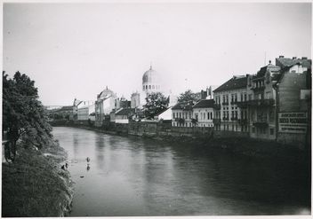
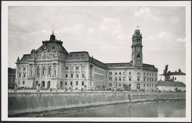
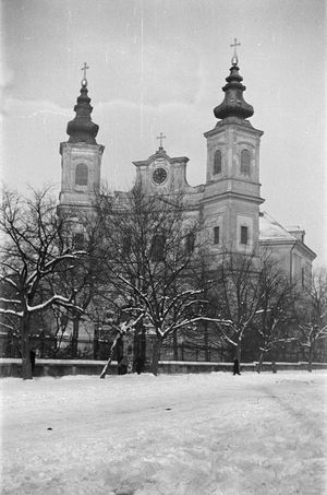
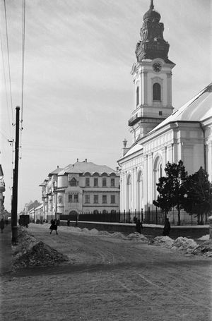
Consequently, from the Mongol invasions in the 13th century until the end of the ‘Turkish Wars’, the Kreischland region – serving as a staging area, transit route and battlefield – experienced a series of devastations, partial depopulations and other consequences of military campaigns. With the newly established Military Frontier serving as a defence against the Ottoman Empire, the resettlement of the areas ravaged by the long wars began under the Habsburgs following the enactment of the first ‘Impopulationspatent’ in 1689. Among other things, the ‘Swabian migration’ of German settlers, who became known asthe ‘Danube Swabians’, also brought about a renewed ethnic differentiation in the Kreischland and Sathmar regions. As in the Banat, checkerboard villages such as Sanktanna (Romanian: Sântana; Hungarian: Újszentanna) were established, particularly in Arad County; Slovak and Bulgarian settlements also sprang up. In the towns of the Kreischland region (e.g. Großwardein, Arad), the Austrian regiment left a visible mark in the form of numerous Baroque buildings that have survived to this day. As was the case for Transylvania in the narrower sense, Habsburg rule ultimately led to a powerful cultural orientation towards the West in the Kreisch region as well.
The Habsburg Monarchy and the 20th century
The Kreischland region became an administrative unit following the establishment of the Habsburg military district of Großwardein, which extended as far south as Arad and as far north as Nyíregyháza and Sathmar. During the Hungarian Revolution (1848–49), Arad became the headquarters of the revolutionaries led by Lajos Kossuth (1802–1894), whilst the Hungarian Diet was relocated to Debrecen. Following the Austro-Hungarian Compromise (1867), efforts at Magyarisationtook place in the Hungarian part of the empire, leading to a percentage increase in the Hungarian population in the Kreisch region.
The period of economic prosperity around 1900 was reflected in numerous Art Nouveau ensembles in the centres of the larger towns, most of which have survived to this day.
The 20th century brought significant territorial changes to the Kreisch region on several occasions. Following the First World War and the end of the Austro-Hungarian Monarchy, the Treaty of Trianon resulted not only in Transylvania being ceded to Romania, but also in the Banat region —which had previously been Hungarian— (a quarter of which went to Serbia) and the Partium, with a border that did not take account of the historical county boundaries but was based primarily on ethnographic realities and the strategic interests of the victorious powers. Under the Second Vienna Award in 1940, the northern part of the district, including the town of Großwardein, Northern Transylvania (a crescent-shaped strip comprising the towns of Klausenburg/Cluj-Napoca [Hungarian: Kolozsvár] and Sankt Georgen [Romanian: Sfântu Gheorghe, Hungarian: Sepsiszentgyörgy]) and the counties of Maramureș and Satu Mare were annexed to Hungary. The borders drawn by the award were annulled de facto in 1945 and de jure in 1947 at the Paris Peace Conference, and the status established by the Treaty of Trianon was restored.
During the Second World War, the region was, amongst other things, the scene of the ‘Debrecen Offensive’, a Red Army offensive in October 1944, in which the 2nd Ukrainian Front of the Red Army, as well as the Wehrmacht’s Army Group South and Army Group F (comprising German and Hungarian units), engaged in heavy fighting, which left behind extensive destruction in several towns and villages (particularly Debrecen). The Jewish population of the northern part of the Kreisch region, which had been annexed by Hungary, was largely deported in 1944 following the Wehrmacht’s occupation of Hungary (‘Operation Margarethe’) and murdered in the Nazis’ extermination camps.
The communist era brought centralised control of agriculture and industry to the Kreisch region, an economically marginalised area of Romania, alongside the general nationalisation of the economy. However, as relatively little heavy industry was established in the region, the legacy of communism was relatively effectively dismantled during the post-reunification conversion processes, and the region is now able to benefit from a modest economic upturn, at least in its urban areas; its proximity to Western Europe acts as a catalyst in this regard.
Population and Religion
The Kreisch region has always had an ethnically mixed population. Historically, the Hungarian population lived mainly in the towns and on the plains, whilst the Romanian population lived in the mountainous areas and the foothills of the Apuseni Mountains. Following the Austro-Hungarian Compromise of 1867, the proportion of the Hungarian population increased considerably; conversely, the proportion of the Romanian population rose after 1920. The proportion of Roma is likely to be somewhat higher at present than the censuses indicate, as many Roma do not declare their ethnicity in these surveys. It is worth noting that, prior to the Shoah and emigration, the proportion of the Jewish population in the counties of Bihor and Sathmar was higher than in Transylvania in the narrower sense.
Ethnic composition of the population in the Romanian counties of the Kreisch region (the order follows that of the census):[1]
| Arad County 1930 | Arad County 2011 | Sathmar County 1930 | Sathmar County 2011 | Bihor County 1930 | Bihor County 2011 | |
| Romanians | 304,838 | 340,670 | 147,135 | 188,155 | 308,478 | 366,245 |
| Hungary | 88,542 | 36,568 | 95,104 | 112,580 | 171,907 | 138,213 |
| Roma | 6,806 | 36,568 | 4,787 | 17,388 | 6,211 | 34,640 |
| Ukrainians | 833 | 1,261 | 3,439 | 1,340 | 808 | 101 |
| German | 58,639 | 2,909 | 24,893 | 5,006 | 2,370 | 735 |
| Lipovans/Russians | 450 | 33 | 1,371 | 6 | 516 | 32 |
| Serbs, Croats, Slovenes | 3,808 | 859 | -- | -- | -- | -- |
| Slovaks | 11,978 | 4,462 | 695 | 125 | 12,365 | 6,091 |
| Bulgarians | 2,391 | 549 | -- | -- | -- | -- |
| Jews | 9,445 | 116 | 23,164 | 36 | 23,709 | 176 |
In addition to the ethnic groups listed in the table, there are also smaller numbers of Greeks, Turks, Czechs, Poles and Armenians living in the Romanian region of Crișana. Some small towns in the west of Bihor County and, above all, many towns in Sathmar County have a high proportion of Hungarians, often constituting a Hungarian majority. The border town of Nadlak (German/Slovak; Romanian: Nădlac; Hungarian: Nagylak) in the far west of Arad County is one of the most important centres of the Slovak minority in Romania; with a population of just over 3,000, they still constitute the absolute majority in the town. In Bihor County, there are significant numbers of Germans in Großwardein (336) and in the village of Neupalota, part of the municipality of Sântandrei (213). Towns and municipalities with larger German populations in Arad County include, amongst others, Arad (1,259), Sanktanna (333), Pankota (German/Hungarian; Romanian: Pâncota; 144) and Glogowatz (Romanian: Vladimirescu; Hungarian: Öthalom; 128). In Sathmar County, Germans live, amongst others, in the towns of Sathmar (1,044) and Großkarol/Carei/Nagykárol ( 479), as well as, for example, in the municipalities of Petrifeld (Romanian: Petrești; Hungarian: Mezőpetri; 434), Fienen (Romanian: Foieni; Hungarian: Mezőfény; 384), Bildegg (Romanian: Beltiug; Hungarian: Krasznabéltek; 368), Schinal (Romanian: Urziceni; Hungarian: Csanálos; 346) and Kalmandi (Romanian: Cămin; Hungarian: Kálmánd; 314) (as at 2011).
This ethnic diversity is also reflected in the data on the religious composition of the population (see table) in the three Romanian counties of the Kreisch region. This religious diversity was further reinforced by the fact that the historic Hungarian East was scarcely affected by the Habsburgs’ Counter-Reformation efforts. Consequently, the sizeable Hungarian minority in particular belongs to the Reformed or Roman Catholic Churches, whilst the Romanians are predominantly Orthodox. Across all three counties combined, barely 200 residents profess the Jewish faith, as the Jewish communities were virtually wiped out following the Shoah and the years of communism. Armenians, members of free church movements, Jehovah’s Witnesses, etc., account for a fraction of a per mille; atheists and those who declined to provide information on their religion also make up a small fraction of a per mille.
Religious affiliation in the Romanian districts of the Kreisch region in 2011 (in the order given in the census):[2]
| Religious affiliation in 2011 | Arad | Bihor | Satu Mare |
| Romanian Orthodox | 430,629 | 575,398 | 575,398 |
| Roman Catholic | 298,252 | 321,312 | 160,776 |
| Protestant | 35,623 | 48,350 | 59,550 |
| Pentecostals | 9,811 | 95,250 | 60,343 |
| Greek Catholic | 28,922 | 37,960 | 9,993 |
| Baptists | 4,271 | 12,184 | 24,568 |
| Adventists | 14,700 | 21,934 | 1,937 |
| Muslims | 4,531 | 1,839 | 863 |
| Free Church Brethren Movement | 1,042 | 1,283 | 3,841 |
| Serbian Orthodox | 3,351 | 310 | 107 |
| Non-denominational | 872 | 1,405 | 838 |
In the parts of the Kreisch region that belong to Hungary, the Hungarian population constitutes a clear majority. The town of Békéscsaba in Békés County had a predominantly Slovak population (around 75 per cent) until around 1900; by 2011, this had fallen to around six per cent, compared with a majority of 83 per cent Hungarians. The town of Békés, situated slightly further north on the Kreisch, has a Slovak minority as well as a Romanian population accounting for around five per cent. In the county, alongside the Hungarian majority, there is a minority of around two per cent Slovaks, around one per cent each of Romanians and Roma, 0.5 per cent Germans, and a small number of Serbs. The historic county town of Gyula, the birthplace of Albrecht Dürer the Elder (born c. 1427–1502), currently has approximately 3.5 per cent Romanian and 3.5 per cent German inhabitants; in the Gyula sub-region, the town of Elek (German/Hungarian; Romanian: Aletea) also had a sizeable German-speaking population and still has a Romanian community today.
In the two other counties comprising parts of the historic Kreisch region and Sathmar, the situation is similar, with declining minority populations. Debrecen, the ‘Rome of the Calvinists’, is the centre of the Evangelical Reformed Church in Hungary. In the 2011 census, 84 per cent were Hungarians, 1.3 per cent Roma, 0.3 per cent Germans and 0.2 per cent Romanians; just over 15 per cent did not provide any information on their ethnic origin. The religious composition in Debrecen in 2011 is also noteworthy: 24.8 per cent Hungarian Reformed; 23.4 per cent Roman Catholic; 5.1 per cent Greek Catholic; 0.4 per cent were Baptists, 0.4 per cent were Jehovah’s Witnesses and 0.4 per cent were Lutherans; 26 per cent stated that they did not belong to any denomination, whilst 28.4 per cent refused to provide information on their religious affiliation. These inconsistent figures reveal two things: on the one hand, the complex religious landscape; on the other, the high degree of secularisation in post-communist Hungary.[3]
The proportion of the Jewish population that was not a victim of the Shoah and persecution by the Hungarian Arrow Cross Party (an anti-Semitic Hungarian party, 1935–1945) (less than a third of the Jews living in Hungary within the 1944 borders) emigrated almost in their entirety in the post-war years.
4. ‘Sathmar Swabians’ – Germans in the Kreisch region and in Sathmar
The Sathmar Swabians were a distinct group of settlers who came to the Kreisch region to repopulate the border areas with the Ottoman Empire, which had been devastated by wars, epidemics and natural disasters. They belong to the group of settlers commonly referred to collectively asthe ‘Danube Swabians’, who were brought to the regions along the Military Frontier through measures taken by the Habsburgs and/or on the initiative of the landowners. Predecessors of this main settlement group had been migrating to the area around Sathmar since the 11th century as miners, craftsmen and farmers, endowed with privileges similar to those of the Transylvanian Saxons (charter of 1230 granted by King Andrew II [1177–1235]), but largely assimilated due to their small numbers.
The Sathmar Swabians were settlers from Württemberg who had been summoned to their devastated homeland by the Hungarian Károlyi family of counts shortly after the end of the Kuruc Wars (1711). The first wave, which did not lead to permanent settlement, was followed by further waves from 1720 onwards, with the result that by 1900 some 40 settlements had sprung up around the Sathmar Swabian ‘centre’ of Großkarol. Economically, the Sathmar Swabians devoted themselves to livestock farming and agriculture, particularly viticulture, which also gave rise to the distinctive architectural feature of the ‘cellar villages’ on the slopes of the Buchen Mountains.
From as early as the beginning of the 19th century, the Sathmar Swabians were subjected to the Hungarians’ efforts at Magyarisation. Gradually, their own German-speaking administration, including the education system, disappeared; the Catholic Church proved, for the most part, to be an active agent of Magyarisation, opposed only by a few clergymen (such as Michael Haas [1810–1866]). By 1918, German no longer existed as a language of instruction in the Sathmar region. As Greater Romania, to which the region belonged from 1918/19 onwards, had committed itself to recognising minority rights, German-speaking educational institutions were re-established, but above all to remove the Sathmar Swabians from the Hungarian cultural sphere, which the Romanian government perceived as a greater threat – due to the region’s proximity to the border – than the Swabians’ German identity. In 1939, there were 31 schools with a German section; following a brief ban during the communist era, kindergartens were added (after 1957), and in the post-reunification period, grammar school streams were also introduced. The number of Sathmar Swabians never exceeded 25,000 (see ‘Population and Religion’).
The Germans settled in Bihor (not very numerous) are also counted among the Sathmar Swabians (as are the Germans in the counties of Salaj – 57 in 2011 – and Marmarosch – 1,059 in 2011, predominantly in Frauenbach [Romanian: Baia Mare; Hungarian: Nagybánya] and Oberwischau [Romanian: Vișeu de Sus; Hungarian: Felsővisó]). North of the Maros, which forms the border of the Banat, scattered settlements sprang up on the initiative of landowners, such as in Sanktanna in Arad County (these are counted amongst the Banat Swabians); during the Josephine Swabian settlement campaign, Neupalota (now the municipality of Sântandrei), west of Großwardein, emerged as the only planned settlement in the historic county of Bihar.
Compared to the Banat, with its high proportion of German inhabitants, and Sathmar, where there was also a denser German settlement, settlement activity in Bihor County was very limited. One reason for this was that, following the ‘Turkish Wars’, this county was by no means as severely ravaged as the Banat. Secondly, there were fewer opportunities for German settlers in Bihor County; agriculture was in the hands of the Hungarians (the plains, arable farming) and the Romanians (the mountainous regions, livestock farming). With regard to the presence of (Austrian) Germans, the Habsburg administration and the Catholic clergy played a particularly significant role here (cf. the memoirs of Ditters von Dittersdorf [1739–1799][4]) and the garrisons in the towns played a particularly significant role. Western cultural trends were transmitted via the centres of the Habsburg Monarchy.
Only the Sathmar Swabians have developed a distinct group identity; the settlers in Arad County are generally counted amongst the Banat Swabians and identify themselves with this designation.
The Germans currently living in the Romanian part of the district are organised within the DFDR’s North Transylvania Regional Forum in the district forums of Sathmar and Bihor and in numerous subordinate local forums, as well as within the Banat Regional Forum in the Arad local forum and in six further local forums.
In some villages in Sălaj, DFDR candidates have been elected as mayors (2012: seven).
5. Discourses and controversies
The Kreisch region is an example of the semantic loading of region-specific spatial constructs with national political symbolism. The significance of natural boundaries, which was still evident in the ‘Barbaricum’ of the Roman Empire, became less prominent during the ‘Turkish Wars’ – here, the region served as a staging ground and transit route, with control changing hands time and again. The region’s affiliation with a particular cultural sphere or a specific imperial entity remains ultimately ambiguous, which – as is typical, for example, of regions in the Balkans – continues to make the area a bone of contention between two nationalist movements to this day; thus the demarcation of the border between Hungary and Romania has been a recurring point of contention since 1918. The Kreisch region and Sathmar played a varying role in the history of Hungary and Romania during the 20th century (both regions were, in turn, inextricably intertwined); certain culture-specific elements attributable to ‘Turkish rule’ point to ‘Balkan’ characteristics, whilst at the same time their roots in the Central European region – through their connection to the Kingdom of Hungary and the Habsburg Empire – are of a qualitatively entirely different nature to those in the Romanian Danubian principalities.
Nor does the ethnic situation in this case provide much insight into the validity of any claims, which consequently led to homogenisation campaigns by the respective ruling states. Evidence of continuous settlement, particularly in the Kreisch region, is a key argument for both sides; consequently, archaeology and historiography are repeatedly exploited for nationalistic ends. To this day, however, the area—which has been continuously inhabited since the Migration Period—is characterised by its multi-ethnicity.
In the wake of the ‘rediscovery of the regions’ in post-communist Eastern Europe, the various regional designations in the Romanian-Hungarian border region have taken on political significance in the context of the ongoing controversies surrounding the national affiliation of Transylvania (in the broader sense). For example, the naming of the Hungarian-funded, Hungarian-speaking private university ‘Partium’ in Nagyvárad emphasises the region’s historical affiliation with Hungary. For instance, there is no Wikipedia entry for ‘Kreischgebiet’ – Hungarian: Körösvidék – in the Hungarian version, whereas there is one for ‘Partium’. Irredentism and the desire for border revision are still evident amongst the significant Hungarian minority living in the Romanian part of the ‘Kreischgebiet’, although the quest for autonomy is not as pronounced as in the Szeklerland region of Transylvania.
Bibliography
- Liviu Borcea: Bihorul medieval [The County of Bihor in the Middle Ages]. Großwardein/Oradea 2005.
- Viorel Faur: Contributions to the History of Bihor County. Großwardein/Oradea 1970.
- Béla Köpeczi (ed.): A Brief History of Transylvania. Budapest 1989 (Hungarian edition: Erdély rövid története. Budapest 1989).
- Paul Niedermaier: Medieval Town Planning in Transylvania, the Banat and the Kreisch region. Part 1: Development from the Beginnings to 1241. Heidelberg 1996; Part 2: Urban Development in the Middle Ages. Transylvania, the Banat and the Kreisch Region (1242–1347). Vienna, Cologne, Weimar 2002; Part 3: Urban Development in the Middle Ages. Transylvania, the Banat and the Kreisch Region (1348–1541). Vienna, Cologne, Weimar 2004.
- Szilla Anna Szabó: Language shift and code-mixing. German–Hungarian–Romanian language contact in a rural community in north-western Romania. Frankfurt am Main et al. 2010 (Variolingua 38) [on Neupalota].
Web links
- mek.oszk.hu/02100/02113/html/241.html (Béla Köpeczi (ed.): A Brief History of Transylvania. Budapest 1989, p. 657: Map showing the border between Hungary and Romania as agreed in the Trianon Treaties, as well as the proposals of the expert commissions, under: Map 24).
- www.biharinaplo.ro (Website of the local daily newspaper ‘Bihari Napló’ [Bihor County], in Hungarian)
- www.crisana.ro (Website of the daily newspaper ‘Crișana’ with news from Oradea and Bihor County, in Romanian)
- www.schwabe.ro (Website of the DFDR, Sathmar County Forum)
Notes
[1] Ethnic groups with fewer than 100 members (in both censuses) are not listed; all figures are based on the official censuses, as published on the website of Romania’s National Institute of Statistics (INSSE) (www.insse.ro).
[2] Only religious denominations with at least 1,000 members in at least one of the three counties are included; data based on the 2011 census, Section 14. Population by ethnicity and religion (Based on census data from the Romanian Institute of Statistics via www.insse.ro); the figures do not correspond to those for ethnicity.
[3] According to the 2011 census data, available on the website of the National Office for Statistics in Hungary (Központi Statisztikai Hivatal): www.ksh.hu/nepszamlalas/docs/tablak/teruleti/09/09_4_1_7_1.xls.
[4] Karl Ditters von Dittersdorf: Autobiography. Dictated to his son. Edited by Norbert Miller. Munich 1967.
Citation
Thomas Schares: Kreischgebiet. In: Online Encyclopaedia on the Culture and History of Germans in Eastern Europe, 2020. URL: ome-lexikon.uni-oldenburg.de/p32596 (accessed 15 December 2020).
Terms of use for this article
Copyright © University of Oldenburg and the Federal Institute for the Culture and History of Germans in Eastern Europe (BKGE), all rights reserved. This work was produced as part of the project ‘Online Encyclopaedia on the Culture and History of Germans in Eastern Europe’ and may be reproduced and published provided the rights holders’ consent has been obtained. Please contact:
If you have any specialist comments or additions to the text, please contact the editorial team, citing relevant literature and source references.