

Tartlau/Prejmer
Tartlau/Prejmer
Location
Tartlau is situated at 45° 43′ north latitude and 25° 46′ east longitude, 17 km north-east of the county town of Kronstadt/Braşov, at an altitude of 519 m above sea level, at the foot of the Bosau Pass (Romanian: Pasul Buzăului).
Common symbolism
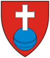
The current coat of arms depicts a white cross on a red background, standing on a blue sphere. It is derived from the village’s cattle brand.
Middle Ages
In 1211, the border river ‘Tortillou’ or ‘Tartelove’ was mentioned in the charter of grant issued by King Andrew II (c. 1177–1235) to the German Order. It is highly likely that the settlement was founded by the Order of Knights and populated by settlers from the Holy Roman Empire and from the County of Sibiu (Latin: comitatus Cibiniensis). In 1240, King Béla IV (1206–1270) granted the patronage over the four Burzenland parishes of Marienburg/Feldioara, Petersberg/Sânpetru, Honigberg/Hârman and Tartlau to the Cistercian monastery at Kerz/Cârța (first documented mention of Tartlau). In 1241, 1278, 1285 and 1335, the town was plundered by the Mongols. Tartlau belonged to the County of Burzenland; from 1377, it belonged to the Burzenland district and, together with twelve other parishes and the town of Kronstadt, formed a judicial and administrative unit; ecclesiastically, the town belonged to the Burzenland chapter both before and after the Reformation. In 1415, the ‘Hann’ (Latin: villicus, village headman) of ‘Tartlaw’ is mentioned in a document, and in 1424 the local judge (Latin: iudex). In 1421, the Ottomans destroyed the village for the first time. In 1460, a village school (headmaster Antonius) is mentioned for the first time. In 1471, the village is referred to as a market town (Latin: oppidum) and remained the largest of the district parishes for a long time. Between 1449 and 1873, the people of Tartlau were embroiled in a seemingly endless legal dispute with the nobles of Kreuzburg (Latin: Cruceburg, a village that no longer exists), and subsequently with the noble family Béldi of Bodeln (Romanian: Budila), in order to preserve their freedoms. Its location at the exit of the Bosau Pass, a gateway to Transylvania, and near other passes in the Carpathian Arc repeatedly exposed Tartlau to external attacks, which necessitated particularly strong fortifications for the church (fortified church, church fortress). A defensive embankment was also presumably constructed around the village as early as the 14th century.
Early modern period
In 1529, Tartlau was razed to the ground by the Moldavian prince Petru Rareş (1483–1546). In 1531, on the orders of Prince Johann Szapolyai (1487–1540), the town was attacked by Stephan Majláth (c. 1489–1550) and the castle was besieged. In 1552, the Moldavian Prince Ștefan Rareș (1531–1552), acting as an ally of the Ottomans, burnt the town to the ground. In 1599 and 1600, the villages of Burzenland were burnt to the ground by the troops of Michael the Brave (1558–1601). In 1611, for the only time in its history, the castle was captured by the troops of Prince Gabriel Báthory (1589–1613) and the village was burnt to the ground. Further raids by Turks, Tatars, Moldavians, Muntenians and Cossacks took place in 1658 and 1687, during which the town was devastated, though the fortified church was unsuccessfully besieged. In 1704, the anti-Habsburg rebels led by Franz II Rákóczi (1676–1735), the Kurucs, plundered the village and burnt it to the ground. In 1706, imperial troops occupied the fortified church.
Modern History and Contemporary History
During the Habsburg period, Tartlau developed into a large community where, alongside agriculture, the craft trades also flourished. The town was struck by several fires, epidemics and earthquakes during the 18th century and in the early 19th century. In the late 1860s, the schoolteacher Johann Copony founded a paper mill, which operated until 1922, when a wool-processing cloth factory was built in its place; this expanded during the communist era to become the town’s largest employer (around 1,500 employees), but which fell into disrepair following the political changes of 1989–90 and was demolished in 2000. A ‘Neu-Tartlau’ garden city estate, planned in 1912, was never realised due to the First World War. The agricultural reforms of 1923 and 1945 hit German farmers particularly hard. In 1945, able-bodied Germans from Tartlau were also deported to the Soviet Union for ‘reconstruction work’. The nationalisation of banks and businesses (1948) and the collectivisation of agriculture (establishment of a collective farm in 1950) led to the town’s economic decline. In contrast, the state-run agricultural enterprise took over trout farming and expanded it.
From the 1960s onwards, the German population began to emigrate to the Federal Republic of Germany, with this trend intensifying after 1977 and culminating in a sort of mass exodus in the early 1990s. In 2007, what is currently Romania’s largest industrial park was opened within the municipal boundaries of Tartlau.
Population
In 1510, Tartlau was home to 230 householders, 4 tenants, 11 widows, 8 paupers, 3 millers, 1 bell-ringer, 12 shepherds and 6 servants.[1]
In 1850, 3,263 people lived in Tartlau; by 1880, the figure had fallen to 3,233. In 1930, the total population of 5,085 comprised 2,279 Germans, 2,211 Romanians and 430 Hungarians.[2] According to the 2011 census, Tartlau had a population of 8,472, comprising 7,349 Romanians, 510 Roma, 154 Hungarians and 71 Germans.[3]
History of Architecture and Art
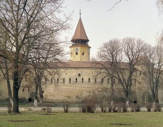
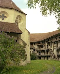
Around 1218, construction began on the Church of the Holy Cross, presumably by the German Order, based on a Greek cross plan. Following a hiatus in construction, the church was completed from 1240 onwards under the patronage of Kerz Abbey in the Cistercian Gothic style (as evidenced by the vaulting and window details). During renovation work between 1461 and 1515, the western arm of the cross was extended westwards. Between 1962 and 1970, extensive restoration work was carried out by the state monument preservation authority; in 1992, the Transylvanian-Saxon Foundation funded further restoration work. The Gothic winged altar dates from the mid-15th century; the choir stalls, dated 1525–1526, feature Renaissance motifs.
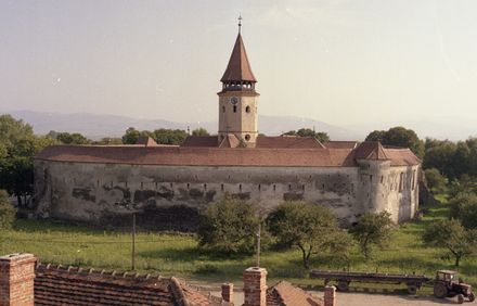
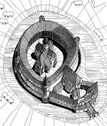
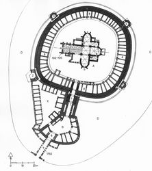
The unfortified Kreuzkirche is surrounded by a particularly massive rampart. The strength of the fortifications is due to the fact that Tartlau is the easternmost Saxon municipality and was therefore particularly vulnerable to enemy troops coming over the Bosau Pass. An initial defensive wall, approximately 3 metres thick, was probably built in the 13th century; it was encased in the 15th century, fitted with a battlemented walkway and reinforced with four flanking towers belonging to the castle. In their present form, the curtain walls are 12–14 metres high and have an average thickness of 4.5 metres. The inner diameter of the enclosure is 72 metres. The outer façade of the outer bailey is decorated with blind arcades in the Renaissance style. Between the outer bailey and the western bailey, a shield wall encloses a courtyard known as the ‘Bäckerhof’. In 1998, the fortified church of Tartlau was designated a UNESCO World Heritage Site.
In addition to the fortified church, theGreek Orthodox Church of Saints Peter and Paul, built in 1791, and the school, constructed between 1846 and 1848, are also listed as historic monuments.[4]
Bibliography
- Erwin Amlacher: The Defensive Function and Systematics of Transylvanian-Saxon Church and Peasant Fortresses. Munich 2002 (Publications of the Institute for German Culture and History in South-Eastern Europe at Ludwig Maximilian University of Munich, Academic Series 95), pp. 150–155.
- Robert Csallner: The Royal Market Town of Tartlau. Sibiu 1930.
- Hermann Fabini: Atlas of Transylvanian Saxon fortified churches and village churches. Sibiu, Heidelberg, Vol. 1. 1998, pp. 727–735.
- Hermann Phleps: In the Footsteps of the First Buildings of the German Order of Knights in the Burzenland Region of Transylvania. Berlin 1927.
- Harald Roth: Prejmer. In: Harald Roth (ed.): Handbook of Historical Sites. Transylvania. Stuttgart 2003 (Kröners Taschenausgabe 330), pp. 144–146.
- Mihaela Sanda Salontai: Biserica fortificată din Prejmer [The Fortified Church of Tartlau]. Bucharest 2006.
- Werner Schunn: Data on the History of the Parish of Tartlau. Böblingen 2005.
- Werner Schunn (ed.): Chronicle of Tartlau in the Saxon Burzenland, provincia Barcensis. Based on Thomas Tartler 1755, Martin Thieskes 1865, Johann Teutsch 1987. Böblingen 1988.
Web links
- www.tartlau.eu/ (German-language website of the Tartlau e. V. Hometown Association, containing a wealth of information on the town’s history, economy and culture)
- www.e-primarii.ro/primaria-prejmer/istorie.php (Romanian-language website of the Mayor’s Office in Tartlau, containing information on the history, culture and current situation of the town)
Notes
[1] Schunn (ed.): Chronicle of Tartlau. Based on Thomas Tartler, p. 27.
[2] Ernst Wagner: Historical and Statistical Gazetteer of Transylvania. With an introduction to the historical statistics of the region. Cologne, Vienna 1977 (Studia Transylvanica 4), pp. 378ff.
[3] Results of the 2011 Census, Volume II, Chapter 8: Ethnic and religious structure of the resident population, broken down by county and the municipalities within them: www.recensamantromania.ro/noutati/volumul-ii-populatia-stabila-rezidenta-structura-etnica-si-confesionala (accessed: 2 December 2015).
[4] See the Register of Historical Monuments in Romania, organised by county and associated localities: patrimoniu.gov.ro/images/LMI/LMI2010.pdf (accessed: 1 December 2015).
Citation
Hermann Fabini, Konrad Gündisch: Tartlau/Prejmer. In: Online Encyclopaedia on the Culture and History of Germans in Eastern Europe, 2015. URL: ome-lexikon.uni-oldenburg.de/p32283 (as at 11 December 2015).
Terms of use for this article
Copyright © University of Oldenburg and the Federal Institute for the Culture and History of Germans in Eastern Europe (BKGE), all rights reserved. This work was produced as part of the project ‘Online Encyclopaedia on the Culture and History of Germans in Eastern Europe’ and may be reproduced and published provided the rights holders’ consent has been obtained. Please contact:
If you have any specialist comments or additions to the text, please contact the editorial team, citing relevant literature and source references.