

Königshütte/Chorzów
Königshütte/Chorzów
Etymology
The name Königshütte is derived from the ironworks of the same name, whose settlements, together with parts of the surrounding parishes, were merged to form the town of Königshütte in 1868. The ironworks was given this name in 1800 in honour of King Frederick William III of Prussia.
Location
50° 18' north latitude, 18° 57' east longitude. Königshütte borders Beuthen/Bytom and Kattowitz/Katowice.
Topography
Königshütte is situated on a plateau that forms part of the Silesian Highlands. The town is rich in coal and ore deposits.
Political and administrative affiliation
Poland. Königshütte is situated in the Silesian Voivodeship. The town is a member of the Upper Silesian Metropolitan Association (Górnośląski Związek Metropolitalny), which was founded in 2007 by fourteen independent towns.
Common symbolism
The coat of arms, granted to the town on 18 October 1869, refers to its affiliation with Silesia, to William I of Prussia (the crown and monogram) and to mining (the hammer and tongs). After 1922, the town – now part of Poland – retained the coat of arms until 1934. It was not until the incorporation of the town of Chorzow/Chorzów that it was granted a new coat of arms, which refers to its affiliation with Upper Silesia and the founding of Chorzów by a knightly order. This coat of arms is still in use today, although during the German occupation (1939–1945) it was replaced by the coat of arms granted by Wilhelm I.
Common nicknames
The nickname ‘The Cradle of Mining’ is occasionally used, although it is also applied to the town of Tarnowitz/Tarnowskie Góry.
Middle Ages
Until the Industrial Revolution, there were only small settlements in the area now occupied by the city, including the village of Chorzów, which was mentioned in a papal document in 1136.
Modern times
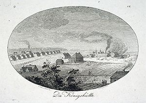
The Royal Smelter in Chorzów (engraving, 1808,
Haselbach Collection) [Herder Institute, Marburg, Image Archive.
Inv. No. P 1355]
At the instigation of the Prussian mining captain (1795–1807, Director of the Silesian Higher Mining Office since 1779) Count Friedrich Wilhelm von Reden (1752–1815), the ‘Carl von Hessen’ coal mine (known as the ‘Königsgrube’ from 1800) was sunk near Beuthen in 1796, following the discovery in 1791 of a coal seam 3 metres thick. In the immediate vicinity, the ‘Königshütte’ was built between 1797 and 1802, and construction of the Königshütte workers’ colony began in 1798. In 1868, the town of Königshütte was founded by decree of Wilhelm I of Prussia. On 1 May 1869, the municipal code was introduced, and on 20 June 1884, the name was changed to “Königshütte Oberschlesien”. On 1 April 1898, the town seceded from the district of Beuthen and was transformed into a municipal district in its own right. In the referendum held in Upper Silesia on 20 March 1921 on national affiliation, 74.75 per cent of the town’s inhabitants voted to remain part of the German Reich; yet, as a result of the division of the voting district, the town was ceded to Poland on 15 May 1922. Its name was translated into Polish as Królewska Huta.
Contemporary History
Following the 1921 referendum, there was a partial exodus of the German population, although a German majority remained represented in the town council. With the incorporation of Neu-Heiduk/Nowe Hajduki and Chorzow in 1934, the town was renamed ‘Chorzów’. These incorporations shifted the balance in favour of the Polish parties, as the newly incorporated areas had a stronger Polish character. In 1939, the municipality of Bismarckhütte/Batory was incorporated.
Following the Wehrmacht’s invasion in 1939, large sections of the Polish population were displaced to the ‘General Government’, and the housing that became vacant was occupied, primarily by German immigrants, until the end of 1944. The air-raid evacuations from major West German cities intensified this process from 1943 onwards. In addition, so-called ‘ethnic Germans’ from south-eastern Europe were resettled in Königshütte.
Prisoners of war and concentration camp inmates were housed there and were forced to work in the industrial plants in place of the Germans who had been called up to the front. Königshütte was home to at least two satellite camps of the Auschwitz concentration camp and five labour camps.
The Red Army captured the town on 28 January 1945 with virtually no fighting and found it undamaged. Flight was prohibited until shortly before the army’s arrival, meaning that large sections of the population remained in the town. The section of the population defined as ‘German’ was partly deported to the Soviet Union or expelled by the Polish authorities across the Oder–Neisse line. However, the expulsion was not carried out as rigorously as in other former parts of the German Reich east of the Oder and Neisse. Skilled workers who were urgently needed were granted the right to remain or were forced to stay. By the end of 1945, 41,000 residents of Königshütte had declared their loyalty to the Polish state.
In addition, Poles from central Poland and the former Polish eastern territories migrated to Königshütte. It was not until the years 1956–1958 that there was an increase in emigration of the German population to the two German states; a second wave of emigration followed after the Warsaw Treaty of 1970.
Population trends
In 1868, the year the town was founded, Königshütte had a population of 14,151.[1] The town grew rapidly during the industrialisation period and, by 1875, was already the largest town in Upper Silesia with a population of 26,040. It retained this position until the early 1920s; since then, a lack of opportunities for expansion has hampered its development.[2]
In 1977, Königshütte’s population peaked at 156,600; since then, the town has lost a good quarter of its inhabitants.[3] With a population of 111,536 in 2012, Königshütte is now the twelfth-largest administrative unit in terms of population within the Upper Silesian industrial region, which comprises 27 towns, municipalities and districts.[4]
Economy and Transport
Owing to abundant coal deposits, the ‘König’ shaft was sunk at the mine in 1797. One of the first steam engines on the European mainland was used here for dewatering. On 25 September 1802, the first coke blast furnace was fired up; at 14 metres, it was the largest in Europe. The works developed well and soon became the largest facility of its kind on the European continent.
For a short time, a spa business flourished using water drawn from the mines, but this disappeared with the advent of industrialisation. Further heavy industry and manufacturing enterprises either established themselves here or were incorporated into the town through municipal amalgamations. The industrial plants were expanded after the Second World War, and the Königsgrube mine was divided into ‘Prezydent’ and ‘Barbara-Wyzwolenie’. Since the structural change, heavy industry has also been in decline in Königshütte: numerous plants have been closed. Small and medium-sized service and retail businesses have only been able to offset the job losses to a limited extent, with the result that the unemployment rate in Königshütte is one of the highest in Upper Silesia.
The first railway line within the town’s present boundaries ran from Schwientochlowitz/Świętochłowice via Heiduk to Myslowitz/Mysłowice from 1847; it was not until 1873 that the town of Königshütte was connected to the railway network. A steam-powered narrow-gauge railway has existed since 1894 and was electrified in 1898.
History of Religion and the Church
In 1871, 83.3 per cent of Königshütte’s inhabitants were Roman Catholics. This figure rose slightly to 86.9 per cent by 1910, whilst the proportion of the Protestant population fell over the same period (from 13.4 per cent to 11.8 per cent), as did that of the Jewish population (from 3.3 per cent to 1.3 per cent).[5]
The Jewish community in Königshütte was established around 1860 and numbered around 5,000 members in 1939 (1871: 500; 1910: 1,500),[6] but also included several neighbouring communities. The large synagogue was built in 1874 and burnt down following the Wehrmacht’s invasion in 1939. Almost the entire Jewish population of Königshütte was deported and murdered.
Special cultural institutions
On the site of the Smelter Park (later known as Reden Park), which was laid out by the smelter management between 1870 and 1872, stands today the Upper Silesian Ethnographic Park (Górnośląski Park Etnograficzne), a cultural and recreational park featuring an open-air museum (with over seventy historic timber-framed buildings from the region), Poland’s largest planetarium (Planetarium Śląskie), a zoological garden (Śląski Ogród Zoologiczny) and the Silesian Stadium (Stadion Śląski).
Education and Science
Some of the institutes of the Silesian University of Katowice are located in Königshütte.
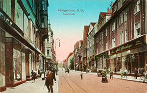
Kaiserstraße, Königshütte/Chorzów (postcard: taken before
1927) [Herder Institute, Marburg, image archive.
Inv. No. 141180]
Everyday culture
In 1920, the football club now known as FC Ruch Chorzów was founded in Königshütte as FC Ruch Bismarkhuta, and in 1923 it was forcibly merged with the German club Bismarckhütter Ballspielclub. In 1939, following the incorporation of Bismarckshütte, the club was renamed KS Ruch Chorzów. After further name changes under German and later Soviet influence, it regained its original Polish name in 1956. Ruch (= ‘the movement’), the record champions, is regarded as the club of the Silesian insurgents and serves as a symbol of Silesian identity for many supporters. To distinguish themselves from the Polish side, the club’s supporters also display banners at home matches bearing the German translation ‘Ruch Königshütte’.
Art History
A number of industrial buildings have been preserved in Königshütte, for example the headframe of the Heinrich (later Elżbieta) shaft, which was decommissioned in 1987, a neo-Gothic structure designed in the style of a castle with a round headframe, as well as the headframe of the Königsgrube (later Prezydent and Polska) mine, which was decommissioned in 1993 and features a steel-frame construction (1933).
Adolph Menzel (1815–1905) painted *The Iron Rolling Mill* between 1872 and 1875, based on sketches he had made at the rail rolling mill in Königshütte; it was one of the first paintings to depict industrialisation as a work process dominated by machines (now in the Alte Nationalgalerie, Berlin).
The oldest church in Königshütte is St Laurentius Church, built in 1599; it is a timber-framed church that was moved from Knurow/Knurów to Königshütte between 1936 and 1938. The Protestant St Elisabeth’s Church (1840–1844) and the Catholic St Barbara’s Church (1852) were built in the Neo-Gothic style, whilst St Anthony’s Church (1931–1934; Adam Ballenstedt) combine Expressionism and Art Deco. During the interwar period, numerous public buildings were constructed in the Modernist style, including the primary schools on ul. 3-go Maja (1929–1931; Wociech Soboń) and on ul. Farna (1930–1932; Karol Schayer, Antoni S. Olszewski), as well as the high-rise building of the Municipal Savings Bank (1936/37; Stanisław Tabeński).
Culture of memory and remembrance
Two monuments hold particular significance in the history of Königshütte: the monument to Count Friedrich Wilhelm von Reden, designed by Theodor Kalide and regarded as one of the ‘fathers of Upper Silesian industry’, was unveiled on the Redenberg in 1853 (damaged in 1939, restored in 1940, re-erected in 1941, destroyed in 1945). In 2002, a new Reden monument was erected on Hüttenplatz. Also of significance is the ‘Monument to the Rebellious Steelworker’, which was erected in 1927 facing north towards the nearest German-Polish border (removed in 1939, re-erected after the war).
The city of Oberhausen became a twin town with Königshütte in 1955. However, only two homecoming gatherings took place, and since the 1970s this twinning has not been actively maintained.
Bibliography
- Sławomir Brzezicki: Chorzów/Königshütte; Chorzów – Batory/Bismarckhütte; Chorzów – Stary Chorzów/Chorzow. In: Ernst Badstübner, Dietmar Popp, Andrzej Tomaszewski, Dethard von Winterfeld (eds.), Sławomir Brzezicki, Christine Nielsen (comp.): Dehio Handbook of Art Monuments in Poland. Silesia. Munich, Berlin 2005, pp. 225–228, p. 228, pp. 228f.
- Peter Chmiel: The Towns of the Upper Silesian Industrial Region after 1945. Outlines of Demographic Development. In: Upper Silesian Yearbook 5 (1989), pp. 107–126.
- Commemorative publication for the ‘Königshütte Reunion’ on 21, 22 and 23 September 1962 in the twin town of Oberhausen (Rhld.). Königshütte. Edited by the Office for Displaced Persons of the City of Oberhausen. Düsseldorf [1962].
- Marian Gałuszka: Chorzów wczoraj. Königshütte yesterday. Gliwice 1996.
- Grzegorz Grzegorek: Encyklopedia Chorzowa [Encyclopaedia of Chorzów]. Chorzów, Erdmannswille, Hajduki Dolne, Hajduki Górne, Królewska Huta, Maciejkowice, Nowe Hajduki, Pniaki, Szarlociniec, Wielkie Hajduki. Katowice 2009 (Small Encyclopaedias of Local Homelands).
- Jenny Mügel: Königshütte. An Attempt at a Description of Early Industrial Architecture Using the Upper Silesian Industrial Region as an Example. Berlin 2004.
- Paul Rother: Chronicle of the Town of Königshütte, Upper Silesia. Dülmen 1994.
- Hugo Weczerka: Königshütte. In: Ibid. (ed.): Handbook of Historical Sites. Silesia. Stuttgart 1977 (Kröners Taschenausgabe 316), pp. 236ff.
Web links
- www.chorzow.eu (Königshütte town website)
- www.muzeumwchorzowie.pl/pl/ (Königshütte Town Museum)
- www.muzeumgpe-chorzow.pl/ (Ethnographic Park Open-Air Museum in Upper Silesia, Königshütte)
- www.sbc.org.pl/dlibra/results?q=K%C3%B6nigsh%C3%BCtte&action=SimpleSearchAction&type=-6&p=0 (Königshütte in the Silesian Digital Library / Śląska Biblioteka Cyfrowa)
- www.herder-institut.de/bildkatalog/wikidata/Q104302 (Images relating to Königshütte/Chorzów in the image archive of the Herder Institute, Marburg)
Notes
[1] Gałuszka: Chorzów yesterday, p. 7.
[2] Hans-Jakob Tebarth: Population and Urban Development in the Opole Administrative District during the Age of Industrialisation. In: Upper Silesian Yearbook 5 (1989), pp. 1–18, here p. 8.
[3] www.stat.gov.pl/cps/rde/xbcr/gus/rs_rocznik_demograficzny_2012.pdf, p. 93 (accessed 27 September 2013).
[4] www.stat.gov.pl/cps/rde/xbcr/gus/rs_rocznik_demograficzny_2012.pdf, p. 44 (accessed 27 March 2013).
[5] Walther Hubatsch (ed.): An Outline of German Administrative History 1815–1945. Series A: Prussia. Vol. 4: Silesia, entry: Königshütte-Stadt district. [Edited by] Johann-Gottfried-Herder Institute, Marburg/L. 1976, pp. 217ff.; Karl Brämer: The Town of Königshütte in Upper Silesia. A Statistical Outline and an Example. In: Journal of the Royal Prussian Statistical Office 31 (1891), pp. 201–226, here p. 207.
[6] Gałuszka: Chorzów wczoraj, p. 8.
Citation
Stephan Müller: Königshütte/Chorzów. In: Online Encyclopaedia on the Culture and History of Germans in Eastern Europe, 2013. URL: ome-lexikon.uni-oldenburg.de/p32531 (as at 30 July 2021).
Terms of use for this article
Copyright © University of Oldenburg and the Federal Institute for the Culture and History of Germans in Eastern Europe (BKGE), all rights reserved. This work was produced as part of the project ‘Online Encyclopaedia on the Culture and History of Germans in Eastern Europe’ and may be reproduced and published provided the rights holders’ consent has been obtained. Please contact:
If you have any specialist comments or additions to the text, please contact the editorial team, citing relevant literature and source references.