

Ösel/Saaremaa
Ösel/Saaremaa
Names in other languages
Swedish: Ösel; Danish: Øsel; Russian: Эзель (Ėzel’) / Сaaремаа (Saaremaa); Latin: Osilia
Etymology
The Estonian name ‘Saaremaa’ and the German name ‘Ösel’ are derived from the term ‘Inselland’. In Scandinavian and Icelandic sagas from the Early Middle Ages, the island is referred to as Eysysla/Eysýsla (‘island district’).
Location and topography
At 2,673 km², Ösel is the largest Estonian island and lies about 20 km west of the Estonian mainland. It is characterised by a flat topography. The island lies at an average elevation of 15 m above mean sea level; Viidu Raunamägi, at 54 m, is its highest point. It stretches approximately 88 km from north to south, whilst the distance between its westernmost and easternmost points is 90 km. Forty per cent of the island is forested.[1]
Political and administrative affiliation
Estonia. Saaremaa, together with the islands ofMuhu,Abruka,Vilsandi andRuhnu, forms the county of Saaremaa (Saare Maakond), covering an area of 2,992 km².[2] This county is divided into the urban municipality (linn) of Arensburg/Kuressaare and thirteen rural municipalities (valda) on the island of Ösel, as well as the island municipalities of Mohn and Runö.
Common symbolism
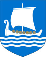
The coat of arms of the district of Ösel was adopted on 5 February 1937 and features a white Viking ship with yellow shields on a blue background, a tribute to Ösel’s past as a Viking port.
Prehistory and Early History
Ösel has been inhabited for around 8,000 years, initially by peoples of Finno-Ugric origin. The oldest archaeological finds date from the 3rd millennium BC. The first fortifications were erected between 1,000 and 500 BC. Finds of early artefacts and tools suggest trade with Germanic and Scandinavian tribes.
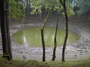
Around 4,000 years ago, a meteorite struck near the village of Kaali, leaving behind eight smaller secondary craters alongside the main crater, which is approximately 50 metres in diameter. Accounts of the impact can be found in Finnish and Scandinavian traditions, as well as in the writings of the Greek geographer Pytheas (c. 350–285 BC). In the 18th and 19th centuries, various theories were put forward regarding the formation of the craters. The German meteorologist and geoscientist Alfred Wegener (1880–1930) first interpreted the site as an impact crater in 1927. In 1937, this theory was confirmed by the geologist I. Reinwald(t).
Middle Ages
The first early historical ship find in the eastern Baltic Sea is the Salme Viking grave, consisting of two Viking boats, which is dated to between 700 and 900 AD. Rune stones bear witness to the presence of the Vikings until around 1050. In 1227, the Livonian Order of the Sword conquered Ösel and placed the island under the jurisdiction of the Diocese of Ösel-Wiek, which also encompassed parts of the Estonian west coast, including the towns of Pernau/Pärnu and Hapsal/Haapsalu. In 1237, the previously independent Order of the Sword Brothers was merged with the German Order and significantly expanded its presence along the Baltic coast. Ösel thus developed into a centre of Christian missionary activity in the eastern Baltic region. With the arrival of German-Baltic members of the Order, settlers and traders, the feudal system began to spread from the late 13th century onwards. There were repeated uprisings and unrest amongst the Estonian population against the German settlers. On 24 July 1343, during the so-called St George’s Night Uprising (Jüriöö ülestõus), Estonian resistance fighters destroyed the church fortress at Peude/Pöide; it was not until the winter of 1345–46 that the German Order was able to restore peace to the island.
Modern times
The rule of the German Order in Western Estonia came to an end in 1559 with the sale of the Diocese of Ösel-Wiek to the Kingdom of Denmark. From 1645 to 1710, Ösel was under Swedish rule, in 1710 it was occupied by the troops of Tsar Peter the Great (1672–1725) during the Great Northern War and, in 1721, was incorporated into Tsarist Russia as part of the Livonia Governorate.
Following the withdrawal of the Teutonic Order in the 16th century, the German-Baltic population organised itself into knighthoods. They were guaranteed class privileges and large landholdings; furthermore, they wielded political influence and assumed responsibility for certain areas of administration. By 1750, 25 Baltic German noble families on Ösel were organised within the Ösel Knighthood.
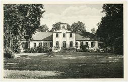
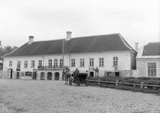
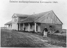
With the abolition of serfdom in 1816, opportunities for gainful employment opened up for the local Estonian population. As part of agricultural reforms, Estonians were permitted to purchase land from their German-Baltic landlords. In 1840, the first spa opened in the capital, Arensburg, and the island developed into a holiday resort for the Russian and German-Baltic upper classes.
Contemporary History
Owing to its location, Ösel was an important base for the Russian fleet during the First World War and the scene of German-Russian clashes. At the end of 1917, German troops captured the island. With the proclamation of the Republic of Estonia on 24 February 1918, Ösel became part of the new Estonian state. Economic and agricultural reforms led to greater competitiveness, and the abolition of the German-Baltic manorial system resulted in the transfer of land ownership to Estonian farmers. Many Baltic German nobles subsequently left the island. The dissolution of the Ösel Knights’ Order, which took place in the same year, was followed in 1920 by the founding of the Ösel Charitable Association by the Baltic Germans who had remained on Ösel; this association existed until 1939. Since 1949, the Ösel Knights’ Order has been organised within the Federal Republic of Germany as part of the Association of Baltic Knights’ Orders (Verband der Baltischen Ritterschaften e. V.).
As a result of the German–Soviet Non-Aggression Pact of 1939, Estonia lost its political independence. In the winter of 1939–1940, the German-Baltic population was resettled to the German Reich. In the course of the Second World War, Soviet troops were stationed on Ösel from 1940 onwards and two air force bases were established. Large sections of the Estonian population were deported or fled across the Baltic Sea to Sweden or Finland. Ethnic Swedes, who had inhabited the island of Runö – part of the Ösel district – since the Middle Ages, left the country entirely. Germany occupied Ösel from 1941 to 1944, but was defeated by Soviet troops on 8 October 1944 in a battle on the Sworbe (Sõrve) peninsula. By the end of the war in 1945, 30 per cent of Ösel’s population had fallen victim to the war, deportations or evacuations.[3]
Under Soviet rule, the island was declared a restricted military zone in 1946 and cut off from the mainland. Political resistance to the Soviet presence on Ösel was mounted by the so-called ‘Forest Brothers’ (medsavennad) until 1964, though they had only a marginal influence on political developments. From 1947, agriculture was collectivised. In 1949, there was a further wave of deportations. In 1989, the restricted zone was lifted. With Estonian independence in 1991, Ösel regained its autonomy, and Russian troops withdrew by 1994.
Population
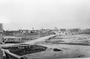
In the early modern period, the population of Ösel fluctuated greatly due to famines, the plague and other diseases. In 1550, approximately 17,500 people lived on the island; by 1627, the figure had fallen to just 12,500.[4] Before the outbreak of the Second World War, the population stood at around 56,000; by the end of the war, it had fallen to around 38,000.[5] The 1934 census recorded 55,851 inhabitants, of whom 54,821 (98.2 per cent) were Estonians, 400 (0.7 per cent) German Balts (of whom 321 lived in Arensburg, where they accounted for 7.2 per cent of the population), 306 (0.5 per cent) Swedes and 194 (0.3 per cent) Russians.[6] The Ösel district is currently home to 39,678 inhabitants (as at 1 January 2014), 94.1 per cent of whom live on the island of the same name. Arensburg is the largest town, with 14,070 inhabitants.[7] The other most populous municipalities on Ösel are Karmel (Kaarma; 4,448), Laisberg (Leisi; 2,051) and Orrisaar (Orissaare; 1,918).[8] Following the withdrawal of theRussian-Soviet military, Ösel has a homogeneous population structure. Approximately 98 per cent of the inhabitants are Estonians, 1.2 per cent are Russians, 0.24 per cent are Finns, 0.22 per cent are Ukrainians and 0.34 per cent are of other origins.[9]
Economy
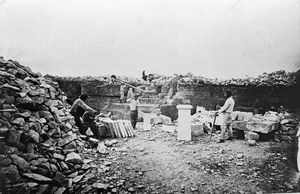
On Ösel, dolomite, limestone, therapeutic mud, mineral water, sand and gravel, as well as clay, are extracted. Shipbuilding has a long tradition and has played a significant role in the economic development of Ösel and its trade links in the Baltic Sea region since the Middle Ages. Today, alongside boat and shipbuilding, the food industry and tourism are the dominant sectors. Following Estonia’s independence in 1991, the electrical industry experienced a strong upswing.
Architecture and Art History
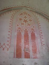
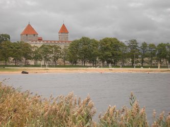
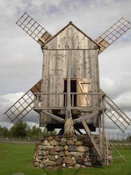
The rule of the German Order is evident in the remains of a fortress near Wolde/Valjala, which was built even before the island’s Christianisation in the 13th century. Not far from the fortress stands St Martin’s Church (Martini Kirik), dating from 1227, which is the oldest church on Ösel. Since Christianisation, and particularly since the Reformation, the landscape has been characterised by farmsteads with their associated village churches. Particularly noteworthy are the interior paintings in the church at Karja, built in the 14th century. To consolidate the Diocese of Ösel-Wiek, the square-shaped Arensburg was built in 1380 in the village of the same name and reinforced with defensive ramparts at the end of the 14th century. With the arrival of German-Baltic members of the Teutonic Order and settlers, the manorial system spread. The oldest manor house on Ösel is Oti Manor in Peude, the first building of which was erected in 1309. From the 19th century onwards, post mills were increasingly built, though only a few have survived, for example in Angla.
History of Books, Printing and Media
The history of the press on Ösel was shaped by German-Baltic publications for over 100 years. The Arensburgische Wochen- oder Intelligenzblätter were published from 1785 to 1794 by the German-Baltic Vice-Governor Balthasar von Campenhausen for the parishes on the island of Ösel. From 1865, the German-language newspaper *Annoncenblatt* was published in Arensburg, followed by the weekly *Arensburger Wochenblatt* from 1875 to 1888.
The first Estonian-language magazine, *Saarlane* (Islanders), was published from December 1883 to 1913. Other Estonian-language periodicals include *Hääl* (The Voice, 1907–1915), *Saaremaa* (Ösel, 1914–1929), *Saaremaa Teataja* (Öseler Anzeiger, 1929–1935), Meie Maa (Our Land, 1919–1949, 1941–1944) and Uus Rahva Hääl (New Voice of the People, 1927–1935). During and after the Second World War, Estonian-language newspapers were under the influence of Soviet ideology: *Saare Hääl* (Voice of the Island, 1940–1941, 1944–1950), Kommunismi Ehitaja (Communist Builder, 1950–1988), Punalipp (Red Flag, 1951–1959), Saare Hääl (1988–1992) and, from 1989, a new edition of *Meie Maa*. Since 1992, the independent newspaper *Oma Saar* (Your Island) has been published; from 1997 to 1998, *Saare Nädalaleht* (Island Weekly) was published; and since 1999, *Saarlane* has been published.
Culture of memory and remembrance
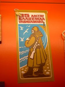
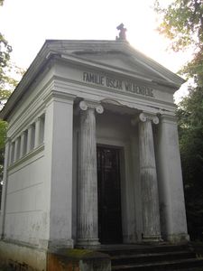
The focus of Ösel’s culture of remembrance is the examination of its German-Baltic and Soviet pasts. The history of Ösel, with a focus on German-Baltic, Russian and Soviet influences, is documented and researched at the Ösel Museum in Arensburg (Estonian: Saaremaa Muuseum). A memorial near the village of Tehhemardi/Tehumardi commemorates the decisive battle of 8–9 October 1944, in which German troops were defeated by the Soviet forces, heralding the start of the Soviet military presence on Ösel. The Kudjapäh (Estonian: Kudjape) cemetery near Arensburg is the final resting place of numerous Baltic Germans spanning several centuries. It also features commemorative plaques for the victims of the Second World War, the deportations and the sinking of the ferry ‘Estonia’. Near the lighthouse in Zerell/Sääre, a memorial was unveiled in 2004 to honour the approximately 4,000 German soldiers who fell on Ösel between 1941 and 1944.
4. Discourses/Controversies
Viktor Kingissepp (1888–1922) is viewed with ambivalence. Born on Ösel, the founder and leader of the Communist Party of Estonia (EKP, Eestimaa Kommunistlik Partei) failed in his attempt to overthrow the Estonian government in a coup in 1922. The Soviet leadership regarded Kingissepp as a martyr and, in 1952, renamed the capital of Ösel, Kuressaare, as Kingisseppa. Even before Estonia gained political autonomy, the name was restored in 1988 under pressure from the population. A historical-critical examination of the figure of Viktor Kingissepp has not yet been undertaken.
Bibliography
- Oskar Baron von Buxhoeveden: On the History of the Knighthoods of Livonia and Oesel. Edited by the Livonian and Oesel Knighthoods. Pfaffenhofen/Ilm 1974.
- Peter W. von Buxhöwden: Essays on the History of the Province of Ösel. Riga, Leipzig 1838. Reprinted in Hanover 1968.
- Hans Feldmann, Gertrud Westermann: Baltic Historical Gazetteer. Estonia (including Northern Livonia). Cologne, Weimar 1985.
- Martin Körber: Ösel Then and Now. Volumes 1–3. Arensburg 1887–1915.
- Marika Mägi: At the Crossroads of Space and Time. Graves, Changing Society and Ideology on Saaremaa (Ösel) 9th–13th centuries AD. Tallinn 2002.
- Neil Taylor: Saaremaa. A History and Travel Guide. Tartu 2008.
Web links
- www.saaremaamuuseum.ee/en/museum/history-of-the-saaremaa-museum/ (English-language website of the Ösel Museum: History of the Ösel Museum)
- www.baltische-ritterschaften-de.de/ritterschaften/oesel/ (website of the Association of the Baltic Knighthoods e. V.: History of the Ösel Knighthood)
- https://www.herder-institut.de/bildkatalog//wikidata/Q31273165 (Images relating to Ösel in the image archive of the Herder Institute, Marburg)
Notes
[1] Welcome to Estonia; Saaremaa Tourism Information: Saaremaa, an island in the Baltic Sea. visitsaaremaa.ee/en/saaremaatouristinformation/
[2] visitsaaremaa.ee/en/ (Note 1).
[3] visitsaaremaa.ee/en/ (note 1).
[4] Taylor: Saaremaa, p. 15.
[5] Statistics Estonia: Database. URL: pub.stat.ee (accessed 14 October 2015).
[6] Ethnic groups by administrative units in 1934. In: Herder Institute (ed.): Documents and Materials on East Central European History. Thematic module ‘Estonia in the interwar period’. URL: www.herder-institut.de/digitale-angebote/dokumente-und-materialien/themenmodule/quelle/1445/details/2189.html (accessed 21 October 2021).
[7] visitsaaremaa.ee/en/ (note 1).
[8] visitsaaremaa.ee/en/(note 1).
[9] pub.stat.ee (note 5).
Citation
Anna Derksen: Ösel/Saaremaa. In: Online Encyclopaedia on the Culture and History of Germans in Eastern Europe, 2015. URL: ome-lexikon.uni-oldenburg.de/p32575 (accessed 15 February 2022).
Terms of use for this article
Copyright © University of Oldenburg and the Federal Institute for the Culture and History of Germans in Eastern Europe (BKGE), all rights reserved. This work was produced as part of the project ‘Online Encyclopaedia on the Culture and History of Germans in Eastern Europe’ and may be reproduced and published provided the rights holders’ consent has been obtained. Please contact:
If you have any specialist comments or additions to the text, please contact the editorial team, citing relevant literature and source references.