
Transdanubia/Swabian Turkey
Transdanubia/Swabian Turkey
Etymology
‘Transdanubia’ means ‘beyond the Danube’ (Latin: Danubius = Danube), as seen from the former capital of Hungary, Pressburg/Bratislava/Pozsony; by contrast, what is now western Slovakia was known as ‘Cisdanubia’. The name ‘Swabian Turkey’ originated in the 18th century, when German colonists (‘Swabians’) were settled by the Habsburgs in this part of Transdanubia, which had belonged to the Ottoman Empire until 1699.
Location and topography
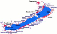
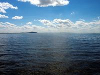
Transdanubia (as it is understood today) covers an area of approximately 42,000 km², bordered to the north and east by the Danube (Hungarian: Duna, Slovak: Dunaj), to the south by the Drava (Hungarian: Dráva, Slovenian and Croatian: Drava ) and to the west by the Alps. The landscape of Transdanubia is varied: to the west lie the foothills of the Eastern Alps; the north-western part consists of the Pannonian Plain with Lake Neusiedl (Hungarian: Fertő-tó), whilst the southern and north-eastern parts are characterised by hilly terrain. In the centre of Transdanubia lies Lake Balaton (Hungarian: Balaton), which, at 594 km², is the largest lake in Central Europe. The highest point in Transdanubia is the summit of Geschriebenstein (Hungarian: Írottkő) at 884 m above sea level in the Günser Mountains (Hungarian: Kőszegi hegység) on the border with Austria.
Historical Geography
Between the end of the 9th century and the First World War, the historic region of Transdanubia formed part of the Kingdom of Hungary. In the 16th and 17th centuries, it was politically divided by theHabsburg–Ottoman border. Since 1919/1920, approximately 37,000 km² have belonged to Hungary, whilst the western edge forms part of the Austrian Federal State of Burgenland (3,961 km²) and the south-western part (947 km²) forms part of the Slovenian region of Prekmurje (Slovenian: Prekmurje); the south-eastern corner (South Branau, Hungarian: Baranya, Croatian: Baranja, approx. 114 km²) belongs to Croatia. Since the First World War, the term ‘Transdanubia’ has essentially been used only to refer to the Hungarian part.
Swabian Turkey is a cultural landscape without defined borders. It is situated in the south-eastern part of Transdanubia, in the counties of Tolnau (Hungarian: Tolna) and Branau (Hungarian: Baranya).
Political history
Between 35 BC and 49 AD, the Romans conquered Transdanubia and established the province of Pannonia. The banks of the Danube were fortified as the Limes and the region was Romanised. Following the division of the Roman Empire (395), Pannonia became part of the Western Roman Empire, which, however, was forced to abandon the province at the beginning of the 5th century. During the Migration Period, the Huns, several Germanic tribes and the Avars appeared in Pannonia; in the 6th century, Slavs settled there. Charlemagne (d. 814) incorporated the region into the Frankish Empire following his victory over the Avar Empire at the beginning of the 9th century.
At the end of the 9th and beginning of the 10th centuries, the region fell to the Magyars and remained part of the Kingdom of Hungary until the 16th century. The first King of Hungary, Stephen the Saint (997–1038), established dioceses and counties which still determine the ecclesiastical and civil administration of Transdanubia today.
Between 1541 and 1566, the Ottoman Empire conquered the southern and eastern parts of Transdanubia in several waves. From 1594 to 1598, the Ottomans ruled in Raab/Győr; in 1600, they conquered Groß-Kanizsa/Nagykanizsa. Ottoman rule continued de facto until 1686–1689 (the ‘Great Turkish War’ 1683–1699); under international law, the Ottoman Empire was obliged to cede this territory to the Habsburg Monarchy in 1699.
In the 18th century, German, Serbian and Hungarian settlers established themselves in the region, which had been depopulated by wars. In the 19th century, an economic and cultural boom began, particularly in the north-western part.
Following the collapse of the Austro-Hungarian Monarchy, the outlying areas of Transdanubia were allocated to Austria and the Kingdom of Serbs, Croats and Slovenes. However, Hungarian volunteer troops succeeded in occupying the territories allocated to Austria, thereby forcing a referendum organised by the Hungarian authorities on the affiliation of Ödenburg/Sopron, in which the majority voted in favour of Hungary. Serbian troops occupied Branau and Fünfkirchen/Pécs until 1921.
During the Second World War, many Jews from Transdanubia were murdered in concentration camps. Numerous towns were destroyed during heavy fighting between German and Soviet troops in 1944–1945. After the war, half of the German minority was expelled by the Hungarian government with the support of the Allies.
Administration
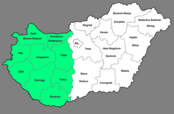
Transdanubia has never constituted an administrative unit. It is now divided into nine Hungarian counties and thirteen cities with county status, which form threeNUTS 2 regions (Western, Southern and Central Transdanubia).
Population
Since the Middle Ages, Transdanubia has been characterised by a settlement pattern consisting of villages and small towns. The region’s largest town, Fünfkirchen, now has a population of just under 150,000.
Since their arrival at the end of the 9th century, Transdanubia has been predominantly inhabited by Magyars.
The population of Transdanubia (excluding Pest County) by mother tongue,1930–2011[1]
| 1930 | 1970 | 1990 | 2011 | |
| Hungarian | 2,317,115 | 3,014,520 | 3,066,342 | 2,535,597 |
| German | 290,456 | 23,316 | 25,976 | 23,261 |
| Croatian | 28,561 | 16,794 | 14,511 | 11,304 |
| Slovenian | 5,277 | 3,364 | 2,449 | 1,569 |
| Slovak | 8,570 | 2,242 | 1,970 | 2,597 |
| Romani and Beasch | 6,942 | 19,612 | 21,970 | 25,081 |
| Other, no answer | 2,542 | 8,227 | 6,746 | 448,275[2] |
German immigrants were invited to settle in this region as early as the time of Hungary’s first kings. In the High Middle Ages, what is now Burgenland was inhabited by a mix of Germans and Magyars. Following the end of Ottoman rule, both the Viennese government and large landowners encouraged the immigration of German colonists. In the late 17th century, German colonists settled in the Ofener Bergland. A century later, their numbers had already exceeded 100,000. The largest settlement campaign was initiated by King Charles III (1711–1740, known as Charles VI, German Emperor): during the 1720s, he invited around 100,000 colonists from Franconia, Württemberg, Bavaria, Hesse and Alsace to the depopulated counties of Branau and Tolnau, which were known as ‘Swabian Turkey’ after the collective name for the so-called‘Danube Swabians’. In the 19th century, a significant proportion of the German population, particularly in the towns, became Magyarised, whilst in the rural communities there was hardly any assimilation. Following the Treaty of Trianon (1920), the Germans of Transdanubia formed Hungary’s largest ethnic minority.
A German nationalist movement was not initiated until the interwar period by Jakob Bleyer (1874–1933), Professor of German Studies at the University of Budapest. The so-called ‘Volksbund’, originally an association for the promotion of German culture and the German minority in Hungary, was founded in 1938 and soon afterwards became the most important instrument of Nazi Germany in winning over the majority of Hungarian Germans to Nazi ideology, as well as in the successful recruitment of Hungarian German men into the Waffen-SS.
After the end of the war, approximately 185,000 Germans were forcibly resettled. As a result of this and through assimilation, the number of Hungarian Germans has declined significantly: in 2011, 23,261 residents of Transdanubia stated German as their mother tongue.
There is a small Croatian minority in the Branau region, a Slovenian minority on the Slovenian border in Zala County, and a Slovak minority in several villages near Budapest. The majority of the Roma population lives in the Branau region.
Economy
The western and northern parts of Transdanubia are among Hungary’s leading economic regions. Of particular importance are mechanical engineering (Audi in Raab, Opel in St Gotthard/Szentgotthárd, Suzuki in Gran/Esztergom) and tourism (Lake Balaton, Lake Neusiedl, Ödenburg, and the spa towns of Heuwies/Hévíz and Wichs/Bük).
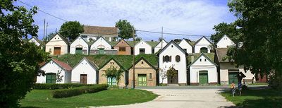
Viticulture is widespread in Transdanubia; the Danube Swabians were particularly active in this field. The most important wine-growing regions are Ödenburg, Lake Balaton, the Ofen Hills, Seksard/Szekszárd and Wieland/Villány.
GDP and unemployment in Transdanubia
| GDP per capita (thousands of Hungarian forints, 2011)[3] | Unemployment rate (%) (1st quarter 2014)[4] | |
| Central Transdanubia | 2,498 | 6.2 |
| Western Transdanubia | 2,871 | 5.1 |
| South Transdanubia | 1,879 | 7.7 |
| Transdanubia in total | 2,428 | 6.3 |
History of Religion and the Church
Christian life existed in Transdanubia as early as Roman times, but it disappeared again during the Migration Period: St Martin of Tours (d. 397) was born around 316/317 in Steinamanger/Szombathely (Latin: Savaria. Early Christian burial sites dating from the fourth century have been preserved in Fünfkirchen; they have been part of the UNESCO World Heritage List since 2000. In the year 996, the last pagan prince of the Magyars, Géza (c. 940–997), initiated the founding of the Benedictine monastery at Martinsberg/Pannonhalma, which remains one of the most important centres of Christianity in Hungary to this day and has been a UNESCO World Heritage Site since 1996. Christianity became established in Hungary in the 11th century. Although the majority of the population of Transdanubia professed the Reformation during the 16th century, most Protestants were reconverted to Catholicism in the 17th century as a result of the Counter-Reformation promoted by the Habsburgs.
According to the 2011 census, of the approximately 3 million inhabitants of Transdanubia, around 1.45 million belong to the Catholic Church, 200,000 to the Reformed Church and 80,000 to the Evangelical Church of Augsburg Confession. 1.2 million are either non-denominational or did not provide any information. The Roman Catholic Church in Transdanubia is divided into seven dioceses (Gran, Raab, Fünfkirchen, Wesprim/Veszprém [founded by Saint Stephen], Stuhlweißenburg/Székesfehérvár, Steinamanger [both founded in 1777], and Kopisch – [also Ruppertsberg]/Kaposvár [1993]). Poppa/Pápa is the seat of a Reformed diocese and a theological academy, and the Evangelical Lutheran Church has a diocese in Raab.
Jews had lived in the region in significant numbers since the 18th century, when Jewish families mostly immigrated from the Alpine countries and the Bohemian lands. The most important communities were established in Raab, Fünfkirchen, Groß-Kanizsa and Poppa. In 1930, more than 60,000 Jews lived in Transdanubia. The Holocaust almost completely destroyed Jewish life in Transdanubia. In the 2011 census, only 920 respondents identified as Jewish.
Religious composition of the population of Transdanubia (excluding Pest County), 1930–2011[5]
| Catholics | Reformed | Lutherans | Jews | Others | No religious affiliation or no answer | |
| 1930 | 2,112,307 | 292,161 | 193,147 | 60,449 | 5,877 | 332 |
| 1,949 | 2,282,191 | 318,336 | 152,054 | 7,443 | 8,306 | 1,332 |
| 2011 | 1,462,900 | 200,511 | 81,922 | 920 | 35,085 | 1,221,877[6] |
Special cultural institutions
Transdanubia is home to several theatres, museums and other cultural institutions. The most important of these are: the Museum of the Martinsberg Benedictine Abbey, the Zsolnay Cultural Quarter (Zsolnay Kulturális Negyed) with the Kodály Centre, the former mosques in Ötkövesd, and the Iseum Savariense Museum in Steinamanger. The Deutsche Bühne Ungarn in Seksard is the only German-language theatre in Hungary. There is also a Croatian theatre (Pécsi Horvát Színház) in Pécs.
Education
In 1367, King Louis the Great (1326–1382, reigned from 1342) founded a ‘studium generale’ in Pécs, but this was closed at the beginning of the 15th century. It was not until 1921 that a university was established here, based on the Hungarian Elisabeth University, which had been relocated from Pressburg. Today, the University of Pécs (Pécsi Tudományegyetem) is one of Hungary’s largest universities. Other universities are located in Raab, specialising in technical sciences; in Wesprim (specialising in technical sciences); in Kesthell/Keszthely (specialising in agricultural sciences); in Ödenburg (specialising in forestry); and in Kopisch (specialising in animal husbandry).
Bibliography
- Tünde Radek, Anikó Szilágyi (eds.): House Histories. Studies on Hungarian-German Culture in Transdanubia. Veszprém 2006.
- Günter Schödl (ed.): Land on the Danube. Berlin 2002 (German History in Eastern Europe).
- Gerhard Seewann: History of the Germans in Hungary. Marburg 2012 (Studies in East Central European Research 24).
- Ingomar Senz: The Danube Swabians. Munich 1994 (Areas of Expulsion and Expelled Germans 5).
- Ingomar Senz: The National Movement of the Germans in Hungary before the First World War. A Development Caught between Pan-Germanism and Hungarian Domestic Politics. Munich 1977 (Book Series of the South-East German Historical Commission 30).
Notes
[1] According to data from: The population by mother tongue, nationality and gender (Table 1.1.6.1). Aggregated data for the Transdanubian counties: www.ksh.hu/nepszamlalas/tablak_teruleti_02 to www.ksh.hu/nepszamlalas/tablak_teruleti_20 (accessed 4 September 2014).
[2] 436,807 people did not answer this question.
[3] The geographical distribution of GDP (2001): www.ksh.hu/docs/hun/xftp/idoszaki/gdpter/gdpter11.pdf (accessed 4 September 2014).
[4] Unemployment: www.ksh.hu/docs/hun/xstadat/xstadat_evkozi/e_qlf027.html (accessed 4 September 2014).
[5] According to data from www.ksh.hu/nepszamlalas (note 1), Table 1.1.7.
[6] 787,981 people did not answer this question.
Citation
Bálint Varga: Transdanubia/Swabian Turkey. In: Online Encyclopaedia on the Culture and History of Germans in Eastern Europe, 2015. URL: ome-lexikon.uni-oldenburg.de/p32605 (as at 7 February 2022).
Terms of use for this article
Copyright © University of Oldenburg and the Federal Institute for the Culture and History of Germans in Eastern Europe (BKGE), all rights reserved. This work was produced as part of the project ‘Online Encyclopaedia on the Culture and History of Germans in Eastern Europe’ and may be reproduced and published provided the rights holders’ consent has been obtained. Please contact:
If you have any specialist comments or additions to the text, please contact the editorial team, citing relevant literature and source references.