

Border marker for Posen-West Prussia
Border marker for Posen-West Prussia
1. Toponymy
The term ‘Posen-West Prussia Border Region’ is thought to have been coined by Bernhard Schnackenburg (1867–1924), who served as Chief President of the Province of West Prussia from May to August 1919. His aim was to group together the territories west of the Vistula that had remained with the Prussian state – from the provinces of West Prussia and Posen, which had otherwise been largely lost to Poland – in such a way that, bearing a ‘traditional name’, they would continue to serve as a reminder of that loss in the future.
The Province of Posen-West Prussia Border Region was established by the ‘Ostmark Act’ of 22 July 1922, a Prussian law aimed at reorganising the local government and administration in the so-called Ostmark. The province came into existence on 1 August 1922 and coincided geographically with the Schneidemühl/Piła administrative district, which had also been created by this Act. The name for the Prussian province and – following its dissolution – from 1938 onwards for the newly created administrative district of the same name within the Province of Pomerania remained in use until 1945.
Location and administrative structure
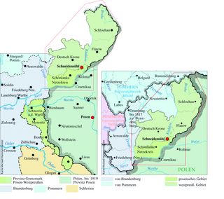
Between 1922 and 1938, the Province of Posen-West Prussia consisted of three non-contiguous areas of varying sizes, which bordered the Prussian provinces of Pomerania, Brandenburg and Silesia to the east. These comprised nine districts: Schlochau/Człuchów, Flatow/Złotów and Deutsch Krone/Wałcz (previously part of the Province of West Prussia) in the north, and, to the south of these, Schneidemühl, Netzekreis, Schwerin an der Warthe/Skwierzyna, Meseritz/Międzyrzecz, Bomst/Babimost and Fraustadt/Wschowa (formerly the Province of Posen). The Netzekreis, with its district administration office in Schönlanke/Trzcianka, was formed on 15 December 1919 from the remaining territories of the German Posen districts of Filehne/Wieleń, Czarnikau/Czarnków and Kolmar/Chodzież. The new district name was a reference to the Netze District, which had passed to Prussia during the First Partition of Poland in 1772. In the districts of Schlochau, Flatow, Meseritz, Bomst, Schwerin an der Warthe and Fraustadt, too, several municipalities had each passed to the new Polish state. From the West Prussian district of Konitz/Chojnice, the greater part of which came under Polish sovereignty, individual municipalities were incorporated into the district of Schlochau in 1919–1920. There were still various changes at the municipal level between the districts of the new province of Grenzmark Posen-Westpreußen.
The seat of the Oberpräsident – who, in the Grenzmark, also served as the Regierungspräsident – was Schneidemühl. The Landeshauptmann, who presided over the Provinzialverband (= a higher-level local authority association within a Prussian province), had his seat in Meseritz. The province covered an area of 7,695 km², with a population of 332,442 (1938). The largest town was Schneidemühl, which had been an independent town since 1914 (population in 1939: 45,791).[1]
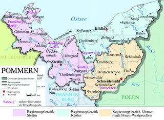
In 1938, the northern part of the Posen-West Prussia Border District, covering a total area of 5,787 km², comprised the districts of Schlochau, Flatow, Deutsch Krone, the Netzekreis and the Schneidemühl municipal district. At that time, 251,000 people lived in 15 towns and 296 rural municipalities. Following the dissolution of the Province of Posen-West Prussia, in which the southern districts were transferred to the provinces of Brandenburg and Silesia, and the creation of the Pomeranian administrative district of the same name – which also incorporated the two Neumark districts of Friedeberg/Strzelce Krajeńskie and Arnswalde/Choszczno were also incorporated, the province of Pomerania grew to a population of 2,393,844 by the time of the census on 17 May 1939, covering a total area of 38,409 km².[2]
Church Administration
After 1919, when the consistories and general superintendents in Berlin and Stettin/Szczecin had temporarily exercised joint ecclesiastical supervision over the Grenzmark region, a Protestant consistory was established in Schneidemühl in 1923 for the new church province of Grenzmark Posen-Westpreußen, which was subdivided into seven superintendencies, within the Prussian Regional Church. This was also where the General Superintendent of the ecclesiastical province had his official residence. After 1938, the Grenzmark was temporarily placed under the jurisdiction of the Berlin consistory and its General Superintendent; and finally, from 1941, a branch office of the Stettin Consistory was officially established in Schneidemühl, thereby incorporating the new administrative district of Grenzmark Posen-Westpreußen into the ecclesiastical province of Pomerania.
On the Catholic side, too, the new state borders resulting from the Treaty of Versailles had made a reorganisation necessary, which took place in several stages. In 1920, an archiepiscopal delegation was established in Tütz/Tuczno, and eventually an Apostolic Administration was established for the territories of the Archdiocese of Gniezno-Poznań (Archidiecezja gnieźnieńska-poznańska) and the Diocese of Chełmno (Diecezja chełmińska) that remained within the German Reich. In 1926, this administration was transferred to Schneidemühl, which was eventually placed under the authority of the Archdiocese of Wrocław (Archidiecezja wrocławska), founded on 13 August 1930, as the Free Prelature of Schneidemühl.[3]
Common symbolism
Like all Prussian provinces, the Border Region of Posen-West Prussia was also to be given a coat of arms and a flag; indeed, as early as the province’s foundation in the summer of 1922, consideration had been given to combining elements from the coats of arms and flags of the former Prussian provinces of Posen and West Prussia. At the heart of the ensuing debates over a suitable coat of arms was the question of how the Posen white eagle could be incorporated into the design in such a way that no Polish claims to the Border Region could be inferred from it. After several rejected designs, on 10 February 1925 the Prussian Ministry of the Interior approved the coat of arms of the Province of Posen-West Prussia, which features, on a silver shield, a black eagle with golden armour and a red tongue, with an arm clad in armour emerging between its neck and right wing, which brandishes a sword with a gold hilt horizontally above the eagle’s head. On its breast, this eagle bears a red heart shield featuring a silver eagle, armed in gold and with a red tongue. However, this new coat of arms was scarcely publicised in the period that followed. Both within the Border Mark and outside the province, there were influential voices opposing the use of the former coat of arms of the Province of Posen in the central shield of the Border Mark’s coat of arms. Consequently, on 28 July 1929, the State Ministry of the Interior in Berlin confirmed an amendment stipulating that the design of the flag – which had been approved by the Provincial Parliament of the Grenzmark on 9 June 1923 – should now serve as the model for a new central shield. This flag displayed, on the side facing the flagpole from top to bottom, the colours of the Province of West Prussia (black–white–black) and, in the opposite field, the colours of the Province of Posen (white–black–white). The latter colours had only been introduced in 1886 to replace the Posen provincial flag in red and white, which had been in use until then.
German territorial losses following the First World War
Even before the end of the First World War, there were signs that the eastern border of the German Empire would not endure (e.g. Woodrow Wilson’s [1856–1924] 14-point programme ). Just a few weeks after the Armistice of Compiègne, a Polish uprising broke out in Posen/Poznań at the end of December 1918. Its aim was the secession of the territories which, during the First and Second Partitions of Poland, in 1772 and 1793, had been incorporated into the Prussian state, in order to form a new Polish Republic from these territories together with those that had also belonged to the Russian Empire and Austria since the Partitions of Poland. Not only the city of Posen, but also large parts of the province of the same name quickly fell under Polish control. Whilst the German side assumed that the parts of the Province of Posen which had not been occupied during the Polish Uprising could remain part of the German Empire, and these were consequently placed under the provisional authority of the District President of the Bromberg/Bydgoszcz administrative district, Friedrich von Bülow (1868–1936), the Treaty of Versailles stipulated that only a narrow strip of land in the west of the Province of Posen was to remain part of the German Empire. Furthermore, the German Empire was forced to cede the greater part of the Province of West Prussia, which at that time was predominantly inhabited by native German speakers. The former Province of West Prussia was divided into four parts: In addition to the westernmost part, comprising German Krone, Flatow and Schlochau – which subsequently became part of the Province of Posen-West Prussia – the easternmost districts of the Province of West Prussia were merged to form the Administrative District of West Prussia, with its seat in Marienwerder/Kwidzyn, which was incorporated into the Province of East Prussia. The north-eastern part, comprising the economic and administrative centre of the Province of West Prussia, was transformed into the Free City of Danzig/Wolne Miasto Gdańsk. The central parts of the Province of West Prussia, on the other hand, fell to the Polish state, which in 1919 created the Pomeranian Voivodeship (Województwo pomorskie) from them; from then on, this was referred to by the Germans as the ‘Corridor’.
From 1919 onwards, most of the German-speaking inhabitants of the former Prussian provinces of Posen and West Prussia – insofar as these fell under Polish sovereignty – left their homeland. The background to this was the option granted to the inhabitants of these areas under Article 297b of the Treaty of Versailles: if they opted to retain German citizenship, they could be expelled; if they chose the new Polish citizenship, they could be refused admission. In both cases, they faced the prospect of expulsion from Polish territory. In the period that followed, the Polish government’s rigid policy towards minorities led to the more or less voluntary emigration of well over half of the German-speaking population. Many found a home in the neighbouring Prussian provinces and, from the early 1920s onwards, formed associations of compatriots from Posen and West Prussia, whose organisational forms at local level already foreshadowed the structures of the East German compatriot associations in western Germany after 1945. Particularly in the context of the settlement of estates – a process that was accelerated as a result of the economic crisis during the interwar period – many refugees from Posen and West Prussia were allocated settlement plots in the region east of the Elbe. Many also found a new home in the Posen-West Prussia Border Region. Not least, the town of Schneidemühl played an important role as a reception and transit centre for refugees from the neighbouring areas to the east.
The origins of the Province of Posen-West Prussia
In 1919, the Prussian Ministry of the Interior in Berlin ordered the consolidation of the western remnants of the provinces of West Prussia and Posen under a single administration, for which a government office was established in Schneidemühl on 20 November 1919. This was, in effect, the Bromberg Regional Council, which had been relocated here. Over the following three years, a wide variety of ideas were put forward as to how to deal with these fragmented territories. These ranged from incorporating them into the neighbouring provinces of Pomerania, Brandenburg and Silesia – whereby a provincial association was to serve as a reminder of these districts’ origins in the former provinces of Posen and West Prussia – to the formation of a new province. Discussions regarding the future administrative structure subsequently took quite different courses at regional and national levels. Whilst in the Grenzmark itself all parties except the KPD favoured the idea of forming a new provincial association and thus achieving autonomy from the three large neighbouring Prussian provinces to the west, a fierce debate erupted in the Berlin State Parliament, in which the SPD, the USPD and the KPD strictly opposed the formation of a ‘Grenzmark Posen-West Prussia’ province on economic grounds, whilst the bourgeois majority in the State Parliament supported the draft bill. The rejection of the Treaty of Versailles – which united large sections of the political public in the Weimar Republic – and the associated revisionism regarding the German Empire’s new eastern border played a central role in this. The name of the province, newly created in the summer of 1922, was part of this political programme; it was characterised by its first Chief President, Friedrich von Bülow, as a ‘promontory’ against feared further Polish territorial claims.[4]
Economic challenges
In the years that followed, the provincial administration in Schneidemühl faced considerable problems arising from the loss of the eastern hinterland. Economic links had been severed. Numerous transport routes, which had been established within the Prussian state since the early 19th century, were severed when the border was drawn in 1919. For example, the loss of the Bentschen/Zbąszyń railway station by the German Reichsbahn and the customs authorities led to the construction of the border station Neu Bentschen/Zbąszynek, situated a few kilometres further west, north of Bomst. Whilst the goods station was completed as early as 1925, the passenger station, the post office and the customs office, built in the Heimatstil architectural style, were not completed until 1930. In total, during these years, just under 400 flats, a Protestant and a Catholic church, the local council offices and other public buildings were constructed for the new town’s population, which consisted mainly of civil servants and their families.
Other public institutions too – ranging from administrative headquarters and hospitals to schools, which in Prussia had always been established to serve the entire province or district in question – were no longer available, as they were often situated in areas that had now come under Polish sovereignty. In all these areas, new structures had to be established. Owing to the economic weakness of the new administrative entity, this was only possible with increased subsidies from the Prussian state; however, during the period of hyperinflation and the subsequent global economic crisis, these could only provide limited assistance. In 1930, the provincial governors of East Prussia, the Posen-West Prussia Border Region, Pomerania, Brandenburg, Lower Silesia and Upper Silesia drafted the 24-page memorandum, * The Plight of the Prussian Eastern Provinces*, printed in Königsberg/Kaliningrad, entitled *The Plight of the Prussian Eastern Provinces*, which was addressed to Reich President Paul von Hindenburg (1847–1934) and in which these provinces were collectively referred to as the ‘Ostmark’. Subsequently, a comprehensive package of legislation was put together under the title ‘Osthilfe’, intended to alleviate the economic hardship in the east of the German Reich and to halt the associated exodus of labour. In public debate, the protection of ‘German identity’ against the looming ‘Polish threat’ was used to secure continued subsidies for the ‘Ostmark’ from the Prussian state and also at Reich level.
One of the most striking examples of this brief phase in the formation of a Grenzmark identity is the new provincial administration building erected on Danziger Platz in Schneidemühl. From an urban planning perspective, an impressive complex was created here between 1925 and 1929 to serve as a public forum, comprising the government building, the Protestant consistory for the Grenzmark church province, the administrative building housing the finance and customs offices, and the Reichsdankhaus for the State Theatre and the State Museum with library, designed by Paul Bonatz (1877–1956), which housed the Landestheater and the Landesmuseum with its library.
Administrative reorganisation following the National Socialists’ rise to power
Following the ‘Prussian Coup’ on 20 July 1932, which saw state authority in the Free State of Prussia transferred to the Reich Government, and the NSDAP’s seizure of power in the German Reich at the end of January 1933, an administrative reorganisation began in many regions, including in the Province of Posen-West Prussia. When the Chief President, Friedrich von Bülow, stepped down from office in January 1933, Hans von Meibom (1879–1960) took over this role. As a member of the DNVP, he resigned from his post immediately after the Reichstag elections of March 1933. Consequently, Wilhelm Kube (1887–1943), the Chief President of the Province of Brandenburg, was entrusted with the administration of the Grenzmark in a dual capacity. In May 1933, the Gau Brandenburg merged with the Gau Ostmark to form the new Gau Kurmark under the leadership of Wilhelm Kube, who had held the post of Gauleiter of the NSDAP in Brandenburg since 1928. A year later, the provincial administration in Schneidemühl was placed under the authority of the Brandenburg High Presidency. Finally, in 1937, administrative responsibility for the Grenzmark was also centralised in Frankfurt an der Oder, where the eastern of the two regional councils of the Province of Brandenburg had its seat.
When the Act on Territorial Reorganisation in the Eastern Prussian Provinces was enacted on 21 March 1938, the development that had been underway since 1933 appeared to have reached its logical conclusion. The Netzekreis, the Schneidemühl urban district, the districts of German Krone, Flatow and Schlochau, as well as the Neumark districts of Friedeberg, Arnswalde and Soldin/Myślibórz, together with the Pomeranian districts of Dramburg/Drawsko Pomorskie and Neustettin/Szczecinek, were to be integrated into the Province of Brandenburg under the name ‘Grenzmark Posen-Westpreußen Administrative District’. The districts of Schwerin an der Warthe, Meseritz and the northern part of the dissolved district of Bomst were to be incorporated into the Brandenburg administrative district of Frankfurt an der Oder, whilst the southern part of the district of Bomst and the district of Fraustadt were to be integrated into the Silesian administrative district of Liegnitz/Legnica. Presumably as a result of the intervention of the influential Pomeranian Gauleiter Franz Schwede-Coburg (1888–1960), an amending act was enacted on 2 September 1938, whereby the planned administrative district of Posen-West Prussia, with its centre at Schneidemühl—though excluding the Neumark district of Soldin—was assigned to the province of Pomerania. The incorporation of the two southern strips of territory from the former province of the Posen-West Prussia Border Region into the provinces of Brandenburg and Silesia, which had already been planned in March, came into effect on 1 October 1938.
When, following the outbreak of the Second World War, the Republic of Poland suffered a military defeat in October 1939, its western territories became part of the German Reich. On 26 October 1939, the Reichsgau Danzig was established, which was renamed the Reichsgau Danzig-West Prussia on 2 November. Whilst three large parts of the Province of West Prussia – which had been dissolved in 1919/1920 – were integrated into this administrative district, comprising the Free City of Danzig, the Administrative District of West Prussia (Marienwerder) and the Pomerellian Voivodeship, three major parts of the Province of West Prussia —which had been dissolved in 1919/1920—were integrated into this administrative district, whilst the western districts remained unchanged within the administrative region of the Posen-West Prussia Borderland in the Province of Pomerania. The same applied to the westernmost districts of the former Province of Posen, which had belonged to the Province of the Posen-West Prussia Border Region until September 1938 and were then annexed to the provinces of Pomerania, Brandenburg and Silesia, where they remained even after the formation of the Reich and Party Gau of Posen on 1 November 1939 – renamed the Reichsgau Wartheland on 29 January 1940.
Despite the administrative arrangements of autumn 1938, special arrangements developed between the provincial administrations now responsible for the former Province of Posen-West Prussia. For example, the ‘Provincial Mental Hospital Obrawalde near Meseritz’, founded in 1904”, which had been situated in the Province of Brandenburg since 1938, was nevertheless placed under the supervision of the Provincial Association of Pomerania as the “Obrawalde Sanatorium and Nursing Home” and administered from Stettin. It gained a grim notoriety in the organisation and execution of the early killings of the mentally ill in the Province of Pomerania, which were among the first mass killings of people classified as ‘mentally ill’ during the Second World War in the German Reich and in the occupied territories.
Annexation by Poland after the Second World War
Until the end of July 1944, when the so-called ‘Pomeranian defences’ were being frantically expanded in anticipation of an attack by the Red Army, the administrative district of Grenzmark Posen-Westpreußen – like the whole of Hinterpommern – was one of the regions in Eastern Central Europe that had scarcely been directly affected by active hostilities during the Second World War. This changed fundamentally with the start of the Red Army’s offensive on the Vistula (Wisła) on 12 January 1945. Owing to its great strategic importance, Schneidemühl was defended particularly vigorously by German troops. The encirclement was held from 28 January to 14 February, before the town too had to be abandoned following a largely unsuccessful attempt to break out. By the start of the winter offensive on 14–15 February 1945, large parts of the Posen-West Prussia border region administrative district were already occupied by Soviet and Polish troops. Arnswalde, which was also encircled, fell on 21 February, Schlochau on 25 February, Neustettin on 27 February and, finally, Dramburg on 4 March. Owing to the course of the front line and the fierce fighting along this line between late January and early March, almost all the towns and countless villages in the administrative district of Grenzmark Posen-Westpreußen were severely to very severely damaged. This observation also applies in full to the districts of the former province of Posen-West Prussia that at that time belonged to Brandenburg and Silesia.
A mass exodus began as soon as the Red Army advanced, followed in the months that followed, under Polish administration, by the expulsion of the remaining German population. In 1945–1946, the territory of the former Province of Posen-West Prussia was divided between the newly created Polish voivodeships of Szczecin (Województwo szczecińskie), Poznań (Województwo poznańskie) and Pomerelia (Województwo pomorskie, known since 1950 as the Bromberg Voivodeship after its administrative centre). Administrative reforms in 1950, 1975 and 1998 led to several changes regarding both the number and size, as well as the names, of the voivodeships in Poland. Under the administrative division in force since 1999, Schlochau belongs to the Pomeranian Voivodeship (Województwo pomorskie), Flatow, Schneidemühl and Schönlanke to the Greater Poland Voivodeship (Województwo wielkopolskie), German Krone to the West Pomeranian Voivodeship (Województwo zachodniopomorskie), and Schwerin an der Warthe, Meseritz, Bomst and Fraustadt to the Lubusz Voivodeship (Województwo lubuskie).
Bibliography
- Thomas Beddies: The Pomeranian Sanatorium and Nursing Home in the Obrawald near Meseritz, Brandenburg. In: Baltic Studies – Pomeranian Yearbooks for Regional History, New Series 84 (1998), pp. 85–114.
- Christian Gahlbeck (ed.): Archive Guide to the History of Eastern Brandenburg up to 1945. Munich 2007 (Publications of the Federal Institute for Culture and History of the Germans in Eastern Europe 31).
- General Directorate of the State Archives of Poland: State Archives in Landsberg an der Warthe – A Guide to the Holdings up to 1945, edited by Dariusz Aleksander Rymar. Munich 2007 (Publications of the Federal Institute for Culture and History of the Germans in Eastern Europe 25).
- Historical and Geographical Atlas of Mecklenburg and Pomerania. Published p.p. by the State Centre for Political Education of Mecklenburg-Western Pomerania. Part 2: Mecklenburg and Pomerania – A Retrospective View of the Region. Schwerin 1997.
- Walther Hubatsch (ed.): An Outline of German Administrative History 1815–1945. Series A: Prussia. Volume 1: East and West Prussia, edited by Dieter Stüttgen; Volume 2: Part 1: Province of Posen, edited by Dieter Stüttgen; Part 2: Province of Posen-West Prussia, edited by Walther Hubatsch. Marburg an der Lahn 1975.
- Peter Johanek, Franz-Joseph Post (eds.), Thomas Tippach (ed.): *Städtebuch Hinterpommern*. Revised edition. Published by the Institute for Comparative Urban History at the University of Münster. Stuttgart 2003 (*Deutsches Städtebuch. Handbuch städtischer Geschichte* 3,2).
- Brigitte and Klaus-Dieter Kreplin (ed.): The Municipalities and Settlements of Pomerania as at 1932, with additions from 1919 to 1945. Parts A and B. Herdecke 1994 (Publications from the Kreplin Genealogical Archive 1A/B).
- Christoph Schley: The Coat of Arms of the Posen-West Prussia Border Region. 89 years ago – the ‘birth’ of the Posen-West Prussia Border Region. In: Pommern – Journal of Culture and History 40 (2002), No. 3, pp. 28–33.
- Karl-Albert Wegener (ed.): Historical Directory of Localities in Hinterpommern. Compiled and edited by the Institute for Applied Geodesy P.p. on behalf of the Federal Ministry of the Interior. Frankfurt am Main 1994 (Series of Historical Directories of Localities for Areas Formerly Belonging to Germany – Period 1914 to 1945, 4).
Web links
- gsta.preussischer-kulturbesitz.de/recherche/thematischer-guide/grenzmark-posen-westpreussen/ Collections relating to the Posen-West Prussia Border Region at the Secret State Archives of the Prussian Cultural Heritage Foundation in Berlin)
- www.herder-institut.de/suche.html?id=103&L=0&q=Grenzmark+Posen-Westpreu%C3%9Fen (collections at the Herder Institute)
Notes
[1] Dietmar Lucht: Pomerania. History, Culture and Economy up to the Outbreak of the Second World War. 2nd ed. Cologne 1998 (Historical Regional Studies – German History in the East 3), pp. 127–128, 182–185.
[2] Eberhard Völker, Manfred Pawlitta (eds.): Pomerania and Eastern Brandenburg. Munich 2000 (Areas of Expulsion and Expelled Germans – Study Series of the East German Foundation for Cultural Affairs 9), p. 99.
[3] Ernst Bahr, Klaus Conrad: Schneidemühl. In: Helge bei der Wieden, Roderich Schmidt (eds.): Handbook of Historical Sites in Germany. Mecklenburg/Pomerania. Stuttgart 1996 (Kröners Taschenausgabe 315), pp. 272–273, here p. 273.
[4] Friedrich von Bülow: The Posen-West Prussia Border Region. In: Friedrich Heiss, Arnold Hillen Ziegfeld (eds.): Germany and the Corridor. Berlin 1933, p. 163.
Citation
Haik Thomas Porada: Border Mark of Posen-West Prussia. In: Online Encyclopaedia on the Culture and History of Germans in Eastern Europe, 2015. URL: ome-lexikon.uni-oldenburg.de/p32545 (as at 4 October 2021).
Terms of use for this article
Copyright © University of Oldenburg and the Federal Institute for the Culture and History of Germans in Eastern Europe (BKGE), all rights reserved. This work was produced as part of the project ‘Online Encyclopaedia on the Culture and History of Germans in Eastern Europe’ and may be reproduced and published provided the rights holders’ consent has been obtained. Please contact:
If you have any specialist comments or additions to the text, please contact the editorial team, citing relevant literature and source references.